Make a donation
Gear up for your next adventure:
As an Amazon Associate, this site earns from qualifying purchases at no extra cost to you.
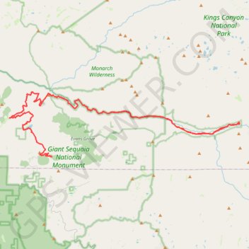
Kings Canyon National Park
- Distance: 54.3 mi
- Elevation gain: 9,049 ft
- Maximum elevation: 6,601 ft
- Elevation loss: 5,879 ft
- Minimum elevation: 3,031 ft
- Moving time: 1 h 57 m
- Moving speed: 27.8 mph
- Maximum speed: 45.4 mph
- Total time: 6 h 16 m
- Global speed: 8.7 mph
Interactive trail map
Make a donation
Gear up for your next adventure:
As an Amazon Associate, this site earns from qualifying purchases at no extra cost to you.
Trail profile
- Distance: 54.3 mi
- Elevation gain: 9,049 ft
- Maximum elevation: 6,601 ft
- Elevation loss: 5,879 ft
- Minimum elevation: 3,031 ft
- Moving time: 1 h 57 m
- Moving speed: 27.8 mph
- Maximum speed: 45.4 mph
- Total time: 6 h 16 m
- Global speed: 8.7 mph
Make a donation
Gear up for your next adventure:
As an Amazon Associate, this site earns from qualifying purchases at no extra cost to you.
About this trail
Name: Kings Canyon National Park trail, distance, elevation, map, profile, GPS track
Start: Kings Canyon Scenic Byway, Fresno County, California, United States (36.81595 -118.81789)
End: Lava-Burton Road, Fresno County, California, 93628, United States (36.75614 -118.87931)
Coordinates: 36.75409 -118.93525 36.83372 -118.58280
Topography: Fresno County topographic map, elevation, terrain
Make a donation
Gear up for your next adventure:
As an Amazon Associate, this site earns from qualifying purchases at no extra cost to you.
Other hiking, mountain biking, running and outdoor activity trails
Click on a trail to view its statistics, map and profile.
Sequoia National Park
United States > California > Fresno County
Distance: 24.3 mi • Elevation gain: 4,472 ft • Maximum elevation: 8,392 ft