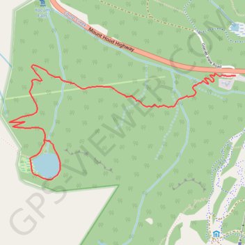
Mirror Lake Loop
Interactive trail map
Trail profile
- Distance: 4.2 mi
- Elevation gain: 827 ft
- Maximum elevation: 4,170 ft
- Elevation loss: 827 ft
- Minimum elevation: 3,609 ft
About this trail
Name: Mirror Lake Loop trail, distance, elevation, map, profile, GPS track
Coordinates: 45.29616 -121.79611 45.30328 -121.77611
Topography: Clackamas County topographic map, elevation, terrain
Other hiking, mountain biking, running and outdoor activity trails
Click on a trail to view its statistics, map and profile.
Mirror Lake Loop Trail in Mount Hood National Forest
United States > Oregon > Clackamas County
The Mirror Lake Loop Trail offers a moderately challenging yet scenic hike that begins in a conifer forest and steadily ascends to the serene Mirror Lake. Along the loop around the lake, you'll be treated to occasional views of the majestic Mount Hood reflected in the water, especially from the west side,…
Distance: 4.4 mi • Elevation gain: 837 ft • Maximum elevation: 4,173 ft
Tom, Dick and Harry Mountain via Mirror Lake Trail in Mount Hood National Forest
United States > Oregon > Clackamas County
The hike to Tom, Dick, and Harry Mountain via the Mirror Lake Trail offers a rewarding experience with diverse natural beauty. Starting at the Mirror Lake Trailhead, the path meanders through lush forests, leading to the Mirror Lake, which reflects the surrounding landscape. Continuing beyond the lake, the…
Distance: 8.2 mi • Elevation gain: 1,795 ft • Maximum elevation: 4,990 ft
Northern part of the Pacific Crest Trail (PCT)
United States > Oregon > Klamath County
Hike on the Pacific Crest National Scenic Trail from Crater Lake to Canada Border through Oregon and Washington along the Sierra Nevada and Cascade mountain ranges. #Hiking #Mountain #SierraNevada #Cascade #Nature #Forest #Park #PCT
Distance: 744.6 mi • Elevation gain: 145,367 ft • Maximum elevation: 7,569 ft