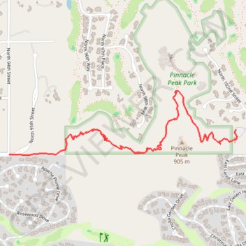
Pinnacle Peak Park
Interactive trail map
Trail profile
About this trail
Name: Pinnacle Peak Park trail, distance, elevation, map, profile, GPS track
Start: Pinacle Peak Trail, Scottsdale, Maricopa County, Arizona, United States (33.72832 -111.86047)
End: Pinacle Peak Trail, Scottsdale, Maricopa County, Arizona, United States (33.72832 -111.86047)
Coordinates: 33.72670 -111.87806 33.73084 -111.86039
Topography: Scottsdale topographic map, elevation, terrain
Other hiking, mountain biking, running and outdoor activity trails
Click on a trail to view its statistics, map and profile.
Pinnacle Peak Trail in Pinnacle Peak Park
United States > Arizona > Maricopa County > Scottsdale
Pinnacle Peak Trail in Scottsdale, Arizona, offers hikers a well-maintained path through the Sonoran Desert, featuring diverse cacti, including the iconic saguaro, and vibrant wildflowers during spring. Along the route, hikers can enjoy panoramic views of the McDowell Mountains and, from Owls Rest, distant…
Distance: 3.5 mi • Elevation gain: 1,047 ft • Maximum elevation: 2,874 ft