Ramapo Mountain Old-School
- Distance: 11.5 mi
- Elevation gain: 1,572 ft
- Maximum elevation: 876 ft
- Elevation loss: 1,572 ft
- Minimum elevation: 226 ft
- Moving time: 2 h 24 m
- Moving speed: 4.8 mph
- Maximum speed: 17.3 mph
- Total time: 3 h 1 m
- Global speed: 3.8 mph
Interactive trail map
Trail profile
- Distance: 11.5 mi
- Elevation gain: 1,572 ft
- Maximum elevation: 876 ft
- Elevation loss: 1,572 ft
- Minimum elevation: 226 ft
- Moving time: 2 h 24 m
- Moving speed: 4.8 mph
- Maximum speed: 17.3 mph
- Total time: 3 h 1 m
- Global speed: 3.8 mph
About this trail
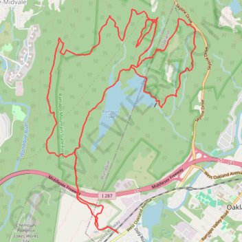
Name: Ramapo Mountain Old-School trail, distance, elevation, map, profile, GPS track
Coordinates: 41.01830 -74.27990 41.05043 -74.25140
Topography: Bergen County topographic map, elevation, terrain
Other hiking, mountain biking, running and outdoor activity trails
Click on a trail to view its statistics, map and profile.
Ramapo Lake and Van Slyke Castle Loop via MacEvoy Trail, Shore Drive, Cannonball Trail and Castle Loop Trail in Ramapo Mountain State Forest
United States > New Jersey > Bergen County > Oakland
This loop offers a scenic hike through Ramapo Mountain State Forest, highlighting both historical ruins and natural beauty. Beginning near Ramapo Lake, the trail passes serene lakeside views, eventually ascending to the eerie remains of Van Slyke Castle, with its crumbling stone walls and overgrown vegetation.…
Distance: 5.6 mi • Elevation gain: 722 ft • Maximum elevation: 876 ft
Afternoon hike at MacEvoy, Castle, and Cannonball Trail Loop
United States > New Jersey > Passaic County > Wanaque
Distance: 5.9 mi • Elevation gain: 741 ft • Maximum elevation: 876 ft
Loop Hike in Ramapo Valley County Reservation
United States > New Jersey > Bergen County > Oakland
Distance: 12.8 mi • Elevation gain: 1,736 ft • Maximum elevation: 1,093 ft
Ramapo Mountain and Lake
United States > New Jersey > Bergen County > Oakland
Distance: 10.0 mi • Elevation gain: 1,243 ft • Maximum elevation: 676 ft