Make a donation
Gear up for your next adventure:
As an Amazon Associate, this site earns from qualifying purchases at no extra cost to you.
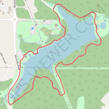
Lake Lenexa Loop in Black Hoof Park
The Lake Lenexa Loop offers a serene hiking experience amidst the hustle of suburban life. The trail meanders around a picturesque 35-acre lake, providing ample opportunities for observing local wildlife, including various waterfowl. With sections of both paved and natural paths, hikers can enjoy a diverse landscape that includes wooded areas and a scenic dam, making it a pleasant outing for nature lovers and families alike. #Hiking #Loop #Lake #Forest #Nature
- Distance: 2.0 mi
- Elevation gain: 118 ft
- Maximum elevation: 958 ft
- Elevation loss: 115 ft
- Minimum elevation: 892 ft
- Moving time: 40 m 56 s
- Moving speed: 2.9 mph
- Maximum speed: 3.7 mph
- Total time: 45 m 1 s
- Global speed: 2.7 mph
Interactive trail map
Make a donation
Gear up for your next adventure:
As an Amazon Associate, this site earns from qualifying purchases at no extra cost to you.
Trail profile
- Distance: 2.0 mi
- Elevation gain: 118 ft
- Maximum elevation: 958 ft
- Elevation loss: 115 ft
- Minimum elevation: 892 ft
- Moving time: 40 m 56 s
- Moving speed: 2.9 mph
- Maximum speed: 3.7 mph
- Total time: 45 m 1 s
- Global speed: 2.7 mph
Make a donation
Gear up for your next adventure:
As an Amazon Associate, this site earns from qualifying purchases at no extra cost to you.
About this trail
Name: Lake Lenexa Loop in Black Hoof Park trail, distance, elevation, map, profile, GPS track
Start: Monticello Road, Lenexa, Johnson County, Kansas, 66227, United States (38.96425 -94.84317)
End: Monticello Road, Lenexa, Johnson County, Kansas, 66227, United States (38.96430 -94.84319)
Coordinates: 38.96065 -94.84469 38.96811 -94.83585
Topography: Lenexa topographic map, elevation, terrain
Make a donation
Gear up for your next adventure:
As an Amazon Associate, this site earns from qualifying purchases at no extra cost to you.