Thank you for supporting this site ❤️
Make a donation
Make a donation
Gear up for your next adventure:
As an Amazon Associate, this site earns from qualifying purchases at no extra cost to you.
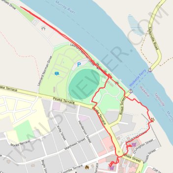
Waikerie clifftop walk
- Distance: 1.9 mi
- Elevation gain: 115 ft
- Maximum elevation: 128 ft
- Elevation loss: 112 ft
- Minimum elevation: 33 ft
- Moving time: 43 m 22 s
- Moving speed: 2.6 mph
- Maximum speed: 4.2 mph
- Total time: 1 h 2 m
- Global speed: 1.8 mph
Interactive trail map
Thank you for supporting this site ❤️
Make a donation
Make a donation
Gear up for your next adventure:
As an Amazon Associate, this site earns from qualifying purchases at no extra cost to you.
Trail profile
- Distance: 1.9 mi
- Elevation gain: 115 ft
- Maximum elevation: 128 ft
- Elevation loss: 112 ft
- Minimum elevation: 33 ft
- Moving time: 43 m 22 s
- Moving speed: 2.6 mph
- Maximum speed: 4.2 mph
- Total time: 1 h 2 m
- Global speed: 1.8 mph
Thank you for supporting this site ❤️
Make a donation
Make a donation
Gear up for your next adventure:
As an Amazon Associate, this site earns from qualifying purchases at no extra cost to you.
About this trail
Name: Waikerie clifftop walk trail, distance, elevation, map, profile, GPS track
Coordinates: -34.17963 139.97938 -34.17118 139.98782
Thank you for supporting this site ❤️
Make a donation
Make a donation
Gear up for your next adventure:
As an Amazon Associate, this site earns from qualifying purchases at no extra cost to you.