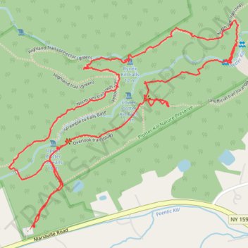
Plotter Kill Falls and Rynex Kill Falls loop via Overlook Trail and North Rim Trail
- Distance: 2.4 mi
- Elevation gain: 371 ft
- Maximum elevation: 873 ft
- Elevation loss: 374 ft
- Minimum elevation: 623 ft
- Moving time: 1 h 12 m
- Moving speed: 2.0 mph
- Maximum speed: 5.9 mph
- Total time: 1 h 23 m
- Global speed: 1.8 mph
Interactive trail map
Trail profile
- Distance: 2.4 mi
- Elevation gain: 371 ft
- Maximum elevation: 873 ft
- Elevation loss: 374 ft
- Minimum elevation: 623 ft
- Moving time: 1 h 12 m
- Moving speed: 2.0 mph
- Maximum speed: 5.9 mph
- Total time: 1 h 23 m
- Global speed: 1.8 mph
About this trail
Name: Plotter Kill Falls and Rynex Kill Falls loop via Overlook Trail and North Rim Trail trail, distance, elevation, map, profile, GPS track
Coordinates: 42.82563 -74.05247 42.83225 -74.04251
Topography: Schenectady County topographic map, elevation, terrain