Thank you for supporting this site ❤️
Make a donation
Make a donation
Gear up for your next adventure:
As an Amazon Associate, this site earns from qualifying purchases at no extra cost to you.
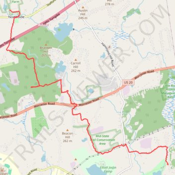
Walking Little River to Midstate Trail through Charlton all the way to Fay Mountain Farm, on CHPT hike
- Distance: 5.3 mi
- Elevation gain: 558 ft
- Maximum elevation: 892 ft
- Elevation loss: 318 ft
- Minimum elevation: 528 ft
- Moving time: 2 h 25 m
- Moving speed: 2.2 mph
- Maximum speed: 5.7 mph
- Total time: 2 h 51 m
- Global speed: 1.9 mph
Interactive trail map
Thank you for supporting this site ❤️
Make a donation
Make a donation
Gear up for your next adventure:
As an Amazon Associate, this site earns from qualifying purchases at no extra cost to you.
Trail profile
- Distance: 5.3 mi
- Elevation gain: 558 ft
- Maximum elevation: 892 ft
- Elevation loss: 318 ft
- Minimum elevation: 528 ft
- Moving time: 2 h 25 m
- Moving speed: 2.2 mph
- Maximum speed: 5.7 mph
- Total time: 2 h 51 m
- Global speed: 1.9 mph
Thank you for supporting this site ❤️
Make a donation
Make a donation
Gear up for your next adventure:
As an Amazon Associate, this site earns from qualifying purchases at no extra cost to you.
About this trail
Name: Walking Little River to Midstate Trail through Charlton all the way to Fay Mountain Farm, on CHPT hike trail, distance, elevation, map, profile, GPS track
Coordinates: 42.13505 -71.95569 42.16614 -71.91180
Topography: Worcester County topographic map, elevation, terrain
Thank you for supporting this site ❤️
Make a donation
Make a donation
Gear up for your next adventure:
As an Amazon Associate, this site earns from qualifying purchases at no extra cost to you.