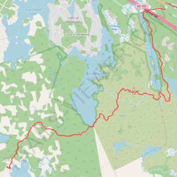
Bluff Wilderness Trails - Hay Marsh Loop
- Distance: 6.7 mi
- Elevation gain: 456 ft
- Maximum elevation: 381 ft
- Elevation loss: 502 ft
- Minimum elevation: 230 ft
- Moving time: 3 h 17 m
- Moving speed: 2.0 mph
- Maximum speed: 4.3 mph
- Total time: 4 h 59 m
- Global speed: 1.3 mph
Interactive trail map
Trail profile
- Distance: 6.7 mi
- Elevation gain: 456 ft
- Maximum elevation: 381 ft
- Elevation loss: 502 ft
- Minimum elevation: 230 ft
- Moving time: 3 h 17 m
- Moving speed: 2.0 mph
- Maximum speed: 4.3 mph
- Total time: 4 h 59 m
- Global speed: 1.3 mph
About this trail
Name: Bluff Wilderness Trails - Hay Marsh Loop trail, distance, elevation, map, profile, GPS track
Coordinates: 44.63034 -63.81196 44.66549 -63.76149
Other hiking, mountain biking, running and outdoor activity trails
Click on a trail to view its statistics, map and profile.
Cranberry Lake and Pot Lake via Bluff Wilderness Trail
Canada > Nova Scotia > Halifax County > Timberlea
Five Bridge Lakes Wilderness Area. #Hiking #Snowshoeing #Loop #FiveBridgeLakes
Distance: 4.6 mi • Elevation gain: 305 ft • Maximum elevation: 420 ft
Halifax - Upper Sackville
Canada > Nova Scotia > Halifax County > Halifax
#Bike #Halifax #UpperSackville
Distance: 21.9 mi • Elevation gain: 1,299 ft • Maximum elevation: 453 ft