Thank you for supporting this site ❤️
Make a donation
Make a donation
Gear up for your next adventure:
As an Amazon Associate, this site earns from qualifying purchases at no extra cost to you.
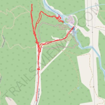
Mamquam Falls
- Distance: 2.3 mi
- Elevation gain: 364 ft
- Maximum elevation: 384 ft
- Elevation loss: 400 ft
- Minimum elevation: 203 ft
- Moving time: 47 m 15 s
- Moving speed: 3.0 mph
- Maximum speed: 13.2 mph
- Total time: 57 m 35 s
- Global speed: 2.4 mph
Interactive trail map
Thank you for supporting this site ❤️
Make a donation
Make a donation
Gear up for your next adventure:
As an Amazon Associate, this site earns from qualifying purchases at no extra cost to you.
Trail profile
- Distance: 2.3 mi
- Elevation gain: 364 ft
- Maximum elevation: 384 ft
- Elevation loss: 400 ft
- Minimum elevation: 203 ft
- Moving time: 47 m 15 s
- Moving speed: 3.0 mph
- Maximum speed: 13.2 mph
- Total time: 57 m 35 s
- Global speed: 2.4 mph
Thank you for supporting this site ❤️
Make a donation
Make a donation
Gear up for your next adventure:
As an Amazon Associate, this site earns from qualifying purchases at no extra cost to you.
About this trail
Name: Mamquam Falls trail, distance, elevation, map, profile, GPS track
Coordinates: 49.71510 -123.09654 49.72254 -123.09142
Thank you for supporting this site ❤️
Make a donation
Make a donation
Gear up for your next adventure:
As an Amazon Associate, this site earns from qualifying purchases at no extra cost to you.
Other hiking, mountain biking, running and outdoor activity trails
Click on a trail to view its statistics, map and profile.