Thank you for supporting this site ❤️
Make a donation
Make a donation
Gear up for your next adventure:
As an Amazon Associate, this site earns from qualifying purchases at no extra cost to you.
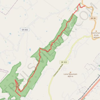
Cumberland Trail Graysville Mountain Trail
- Distance: 9.4 mi
- Elevation gain: 2,280 ft
- Maximum elevation: 1,788 ft
- Elevation loss: 1,529 ft
- Minimum elevation: 879 ft
- Moving time: 3 h 49 m
- Moving speed: 2.5 mph
- Maximum speed: 5.0 mph
- Total time: 4 h 55 m
- Global speed: 1.9 mph
Interactive trail map
Thank you for supporting this site ❤️
Make a donation
Make a donation
Gear up for your next adventure:
As an Amazon Associate, this site earns from qualifying purchases at no extra cost to you.
Trail profile
- Distance: 9.4 mi
- Elevation gain: 2,280 ft
- Maximum elevation: 1,788 ft
- Elevation loss: 1,529 ft
- Minimum elevation: 879 ft
- Moving time: 3 h 49 m
- Moving speed: 2.5 mph
- Maximum speed: 5.0 mph
- Total time: 4 h 55 m
- Global speed: 1.9 mph
Thank you for supporting this site ❤️
Make a donation
Make a donation
Gear up for your next adventure:
As an Amazon Associate, this site earns from qualifying purchases at no extra cost to you.
About this trail
Name: Cumberland Trail Graysville Mountain Trail trail, distance, elevation, map, profile, GPS track
Coordinates: 35.45926 -85.11037 35.52722 -85.04704
Topography: Rhea County topographic map, elevation, terrain
Thank you for supporting this site ❤️
Make a donation
Make a donation
Gear up for your next adventure:
As an Amazon Associate, this site earns from qualifying purchases at no extra cost to you.