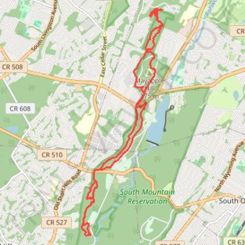
Mayapple Hill & West South Mountain Reservation
- Distance: 9.8 mi
- Elevation gain: 1,106 ft
- Maximum elevation: 614 ft
- Elevation loss: 1,106 ft
- Minimum elevation: 302 ft
- Moving time: 1 h 58 m
- Moving speed: 5.0 mph
- Maximum speed: 13.4 mph
- Total time: 3 h 25 m
- Global speed: 2.9 mph
Interactive trail map
Trail profile
- Distance: 9.8 mi
- Elevation gain: 1,106 ft
- Maximum elevation: 614 ft
- Elevation loss: 1,106 ft
- Minimum elevation: 302 ft
- Moving time: 1 h 58 m
- Moving speed: 5.0 mph
- Maximum speed: 13.4 mph
- Total time: 3 h 25 m
- Global speed: 2.9 mph
About this trail
Name: Mayapple Hill & West South Mountain Reservation trail, distance, elevation, map, profile, GPS track
Start: Cedar Avenue, West Orange, Essex County, New Jersey, 07052, United States (40.77387 -74.28697)
End: Cedar Avenue, West Orange, Essex County, New Jersey, 07052, United States (40.77390 -74.28696)
Coordinates: 40.74042 -74.30614 40.78610 -74.28445
Topography: Essex County topographic map, elevation, terrain
Other hiking, mountain biking, running and outdoor activity trails
Click on a trail to view its statistics, map and profile.
Hemlock Falls Loop
United States > New Jersey > Essex County > Maplewood
Starting from the South Orange Avenue access, this loop enters South Mountain Reservation on the Crest Trail and follows a shaded woodland corridor before joining Openwood Trail and curving deeper into the forest. The route then uses Lenape Trail and the local Hemlock Falls Loop to reach Hemlock Falls on…
Distance: 1.6 mi • Elevation gain: 220 ft • Maximum elevation: 535 ft
Hemlock Falls Loop via Lenape Trail, Washington Rock, Rahway Trail, and River Trail in South Mountain Reservation
United States > New Jersey > Essex County > Short Hills
The Hemlock Falls Loop offers a delightful hiking experience that combines lush woodlands and stunning views. Along the trail, hikers will encounter the picturesque Hemlock Falls, a striking 25-foot waterfall, as well as Washington Rock, which provides breathtaking vistas of the surrounding area. The trail is…
Distance: 6.0 mi • Elevation gain: 791 ft • Maximum elevation: 554 ft
Hemlock Falls Loop via Rahway Trail and Lenape Trail in South Mountain Reservation
United States > New Jersey > Essex County > Short Hills
The Hemlock Falls Loop in South Mountain Reservation offers hikers a moderately challenging journey through diverse landscapes. Along the route, you'll encounter charming spots like the Rahway River, the Hemlock Falls, the Ball's Bluff—with its intriguing stone pillars—the Maple Falls, and the historic…
Distance: 6.1 mi • Elevation gain: 771 ft • Maximum elevation: 554 ft
Turtle Back Trail and Zoo Loop in South Mountain Reservation
United States > New Jersey > Essex County > West Orange > Saint Cloud
Distance: 12.3 mi • Elevation gain: 1,368 ft • Maximum elevation: 600 ft
South Mountain Reservation Loop via Turtle Back Trail
United States > New Jersey > Essex County > West Orange > Saint Cloud
Distance: 12.5 mi • Elevation gain: 1,437 ft • Maximum elevation: 597 ft
Turtle Back Fatbiking in South Mountain Reservation
United States > New Jersey > Essex County > West Orange > Saint Cloud
Distance: 8.9 mi • Elevation gain: 1,106 ft • Maximum elevation: 600 ft
South Mountain Reservation Loop trails
United States > New Jersey > Essex County > West Orange > Saint Cloud
Distance: 10.9 mi • Elevation gain: 1,276 ft • Maximum elevation: 600 ft
Turtle Back Mountain Biking
United States > New Jersey > Essex County > West Orange > Saint Cloud
South Mountain Reservation
Distance: 10.0 mi • Elevation gain: 1,240 ft • Maximum elevation: 600 ft
Turtle Back Maze
United States > New Jersey > Essex County > West Orange > Saint Cloud
Distance: 9.4 mi • Elevation gain: 1,135 ft • Maximum elevation: 600 ft