Make a donation
Gear up for your next adventure:
As an Amazon Associate, this site earns from qualifying purchases at no extra cost to you.
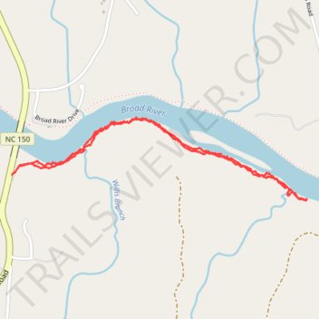
Broad River Southside trail
- Distance: 2.4 mi
- Elevation gain: 154 ft
- Maximum elevation: 686 ft
- Elevation loss: 135 ft
- Minimum elevation: 630 ft
- Moving time: 1 h 15 m
- Moving speed: 1.9 mph
- Maximum speed: 7.3 mph
- Total time: 1 h 16 m
- Global speed: 1.8 mph
Interactive trail map
Make a donation
Gear up for your next adventure:
As an Amazon Associate, this site earns from qualifying purchases at no extra cost to you.
Trail profile
- Distance: 2.4 mi
- Elevation gain: 154 ft
- Maximum elevation: 686 ft
- Elevation loss: 135 ft
- Minimum elevation: 630 ft
- Moving time: 1 h 15 m
- Moving speed: 1.9 mph
- Maximum speed: 7.3 mph
- Total time: 1 h 16 m
- Global speed: 1.8 mph
Make a donation
Gear up for your next adventure:
As an Amazon Associate, this site earns from qualifying purchases at no extra cost to you.
About this trail
Name: Broad River Southside trail trail, distance, elevation, map, profile, GPS track
Start: Gaffney Road, Cleveland County, North Carolina, United States (35.19987 -81.66552)
End: Gaffney Road, Cleveland County, North Carolina, United States (35.19944 -81.66597)
Coordinates: 35.19823 -81.66597 35.20213 -81.64884
Topography: Cleveland County topographic map, elevation, terrain
Make a donation
Gear up for your next adventure:
As an Amazon Associate, this site earns from qualifying purchases at no extra cost to you.
Other hiking, mountain biking, running and outdoor activity trails
Click on a trail to view its statistics, map and profile.
Cottonwood Trail
United States > North Carolina > Cleveland County
Distance: 7.7 mi • Elevation gain: 492 ft • Maximum elevation: 807 ft