Make a donation
Gear up for your next adventure:
As an Amazon Associate, this site earns from qualifying purchases at no extra cost to you.
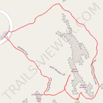
Windows Loop Trail and Turret Arch Trail
Loop hike via Turret Arch, North Window and South Window in Arches National Park #Hiking #Loop #Arch #Desert #Rock
- Distance: 1.1 mi
- Elevation gain: 154 ft
- Maximum elevation: 5,289 ft
- Elevation loss: 154 ft
- Minimum elevation: 5,177 ft
- Moving time: 30 m 24 s
- Moving speed: 2.3 mph
- Maximum speed: 4.0 mph
- Total time: 34 m 3 s
- Global speed: 2.0 mph
Interactive trail map
Make a donation
Gear up for your next adventure:
As an Amazon Associate, this site earns from qualifying purchases at no extra cost to you.
Trail profile
- Distance: 1.1 mi
- Elevation gain: 154 ft
- Maximum elevation: 5,289 ft
- Elevation loss: 154 ft
- Minimum elevation: 5,177 ft
- Moving time: 30 m 24 s
- Moving speed: 2.3 mph
- Maximum speed: 4.0 mph
- Total time: 34 m 3 s
- Global speed: 2.0 mph
Make a donation
Gear up for your next adventure:
As an Amazon Associate, this site earns from qualifying purchases at no extra cost to you.
About this trail
Name: Windows Loop Trail and Turret Arch Trail trail, distance, elevation, map, profile, GPS track
Start: Windows Road, Grand County, Utah, United States (38.68727 -109.53693)
End: Windows Road, Grand County, Utah, United States (38.68728 -109.53689)
Coordinates: 38.68440 -109.53693 38.68874 -109.53139
Topography: Grand County topographic map, elevation, terrain
Make a donation
Gear up for your next adventure:
As an Amazon Associate, this site earns from qualifying purchases at no extra cost to you.
Other hiking, mountain biking, running and outdoor activity trails
Click on a trail to view its statistics, map and profile.
Windows Loop Trail via Turret Arch in Arches National Park
United States > Utah > Grand County
The Windows Loop Trail via Turret Arch in Arches National Park offers a family-friendly hike through some of the park's most iconic sandstone formations. Along the well-marked path, hikers can explore the North and South Window Arches, collectively known as the Spectacles, which resemble a face wearing…
Distance: 1.3 mi • Elevation gain: 180 ft • Maximum elevation: 5,308 ft
North Window, South Window and Turret Arch Loop Trail in Arches National Park
United States > Utah > Grand County
The North Window, South Window, and Turret Arch Loop Trail in Arches National Park offers a relatively short and accessible hike, making it suitable for families and casual hikers. Along the way, visitors can observe the impressive North Window and South Window arches, as well as the distinctive Turret Arch.…
Distance: 0.7 mi • Elevation gain: 125 ft • Maximum elevation: 5,305 ft