Thank you for supporting this site ❤️
Make a donation
Make a donation
Gear up for your next adventure:
As an Amazon Associate, this site earns from qualifying purchases at no extra cost to you.
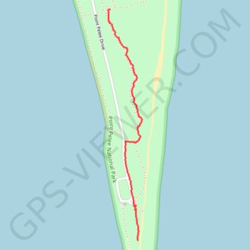
Point Pelee
- Distance: 1.1 mi
- Elevation gain: 13 ft
- Maximum elevation: 581 ft
- Elevation loss: 13 ft
- Minimum elevation: 568 ft
- Moving time: 28 m 19 s
- Moving speed: 2.3 mph
- Maximum speed: 5.0 mph
- Total time: 29 m 54 s
- Global speed: 2.2 mph
Interactive trail map
Thank you for supporting this site ❤️
Make a donation
Make a donation
Gear up for your next adventure:
As an Amazon Associate, this site earns from qualifying purchases at no extra cost to you.
Trail profile
- Distance: 1.1 mi
- Elevation gain: 13 ft
- Maximum elevation: 581 ft
- Elevation loss: 13 ft
- Minimum elevation: 568 ft
- Moving time: 28 m 19 s
- Moving speed: 2.3 mph
- Maximum speed: 5.0 mph
- Total time: 29 m 54 s
- Global speed: 2.2 mph
Thank you for supporting this site ❤️
Make a donation
Make a donation
Gear up for your next adventure:
As an Amazon Associate, this site earns from qualifying purchases at no extra cost to you.
About this trail
Name: Point Pelee trail, distance, elevation, map, profile, GPS track
Start: Point Pelee Drive, Leamington, Essex County, Ontario, Canada (41.91187 -82.50908)
End: Woodland Nature Trail, Leamington, Essex County, Ontario, Canada (41.92484 -82.51115)
Coordinates: 41.91187 -82.51135 41.92484 -82.50876
Thank you for supporting this site ❤️
Make a donation
Make a donation
Gear up for your next adventure:
As an Amazon Associate, this site earns from qualifying purchases at no extra cost to you.