Make a donation
Gear up for your next adventure:
As an Amazon Associate, this site earns from qualifying purchases at no extra cost to you.
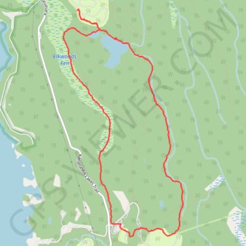
Marl Lake Loop
Peter Lougheed Provincial Park. #Hiking #Snowshoeing #Loop #PeterLougheed
- Distance: 5.4 mi
- Elevation gain: 335 ft
- Maximum elevation: 5,741 ft
- Elevation loss: 335 ft
- Minimum elevation: 5,528 ft
Interactive trail map
Make a donation
Gear up for your next adventure:
As an Amazon Associate, this site earns from qualifying purchases at no extra cost to you.
Trail profile
- Distance: 5.4 mi
- Elevation gain: 335 ft
- Maximum elevation: 5,741 ft
- Elevation loss: 335 ft
- Minimum elevation: 5,528 ft
Make a donation
Gear up for your next adventure:
As an Amazon Associate, this site earns from qualifying purchases at no extra cost to you.
About this trail
Name: Marl Lake Loop trail, distance, elevation, map, profile, GPS track
Start: Paved Path, Kananaskis Improvement District, Alberta, Canada (50.63615 -115.10716)
End: Paved Path, Kananaskis Improvement District, Alberta, Canada (50.63615 -115.10716)
Coordinates: 50.63467 -115.11756 50.66066 -115.09596
Make a donation
Gear up for your next adventure:
As an Amazon Associate, this site earns from qualifying purchases at no extra cost to you.
Other hiking, mountain biking, running and outdoor activity trails
Click on a trail to view its statistics, map and profile.
Whiskey Jack, Tyrwhitt, Elk Pass, Fox Creek and Moraine Trails Loop
Canada > Alberta > Kananaskis Improvement District
Peter Lougheed Provincial Park. #Hiking #MTB #Loop #Forest #PeterLougheed
Distance: 10.8 mi • Elevation gain: 1,250 ft • Maximum elevation: 6,509 ft