Make a donation
Gear up for your next adventure:
As an Amazon Associate, this site earns from qualifying purchases at no extra cost to you.
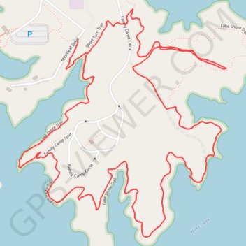
Lake Norman State Park Hike
- Distance: 3.5 mi
- Elevation gain: 220 ft
- Maximum elevation: 840 ft
- Elevation loss: 217 ft
- Minimum elevation: 764 ft
- Moving time: 1 h 6 m
- Moving speed: 3.2 mph
- Maximum speed: 4.9 mph
- Total time: 1 h 11 m
- Global speed: 3.0 mph
Interactive trail map
Make a donation
Gear up for your next adventure:
As an Amazon Associate, this site earns from qualifying purchases at no extra cost to you.
Trail profile
- Distance: 3.5 mi
- Elevation gain: 220 ft
- Maximum elevation: 840 ft
- Elevation loss: 217 ft
- Minimum elevation: 764 ft
- Moving time: 1 h 6 m
- Moving speed: 3.2 mph
- Maximum speed: 4.9 mph
- Total time: 1 h 11 m
- Global speed: 3.0 mph
Make a donation
Gear up for your next adventure:
As an Amazon Associate, this site earns from qualifying purchases at no extra cost to you.
About this trail
Name: Lake Norman State Park Hike trail, distance, elevation, map, profile, GPS track
Start: Short Turn Trail, Iredell County, North Carolina, United States (35.64889 -80.94364)
End: Lake Shore Trail (southern half), Iredell County, North Carolina, United States (35.64941 -80.94408)
Coordinates: 35.64179 -80.94691 35.65065 -80.93690
Topography: Iredell County topographic map, elevation, terrain
Make a donation
Gear up for your next adventure:
As an Amazon Associate, this site earns from qualifying purchases at no extra cost to you.
Other hiking, mountain biking, running and outdoor activity trails
Click on a trail to view its statistics, map and profile.
Lake Shore Loop Trail in Lake Norman State Park
United States > North Carolina > Iredell County
Distance: 7.7 mi • Elevation gain: 686 ft • Maximum elevation: 866 ft
Lake Shore Loop Trail
United States > North Carolina > Iredell County
Distance: 6.2 mi • Elevation gain: 522 ft • Maximum elevation: 866 ft
Lake Shore Loop Trail
United States > North Carolina > Iredell County
Distance: 5.5 mi • Elevation gain: 446 ft • Maximum elevation: 873 ft
Make a donation
Gear up for your next adventure:
As an Amazon Associate, this site earns from qualifying purchases at no extra cost to you.