Make a donation
Gear up for your next adventure:
As an Amazon Associate, this site earns from qualifying purchases at no extra cost to you.
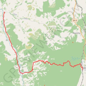
Fishers Track
- Distance: 17.1 mi
- Elevation gain: 1,398 ft
- Maximum elevation: 2,789 ft
- Elevation loss: 3,353 ft
- Minimum elevation: 646 ft
- Moving time: 1 h 25 m
- Moving speed: 12.0 mph
- Maximum speed: 31.9 mph
- Total time: 1 h 34 m
- Global speed: 10.8 mph
Interactive trail map
Make a donation
Gear up for your next adventure:
As an Amazon Associate, this site earns from qualifying purchases at no extra cost to you.
Trail profile
- Distance: 17.1 mi
- Elevation gain: 1,398 ft
- Maximum elevation: 2,789 ft
- Elevation loss: 3,353 ft
- Minimum elevation: 646 ft
- Moving time: 1 h 25 m
- Moving speed: 12.0 mph
- Maximum speed: 31.9 mph
- Total time: 1 h 34 m
- Global speed: 10.8 mph
Make a donation
Gear up for your next adventure:
As an Amazon Associate, this site earns from qualifying purchases at no extra cost to you.
About this trail
Name: Fishers Track trail, distance, elevation, map, profile, GPS track
End: Oio Road, Ruapehu District, Manawatū-Whanganui, 3990, New Zealand (-39.09277 175.24788)
Coordinates: -39.18154 175.24658 -39.09275 175.39388
Make a donation
Gear up for your next adventure:
As an Amazon Associate, this site earns from qualifying purchases at no extra cost to you.
Other hiking, mountain biking, running and outdoor activity trails
Click on a trail to view its statistics, map and profile.
Fishers Track
New Zealand > Manawatū-Whanganui > Ruapehu District > National Park
Distance: 17.1 mi • Elevation gain: 1,394 ft • Maximum elevation: 2,789 ft