Thank you for supporting this site ❤️
Make a donation
Make a donation
Gear up for your next adventure:
As an Amazon Associate, this site earns from qualifying purchases at no extra cost to you.
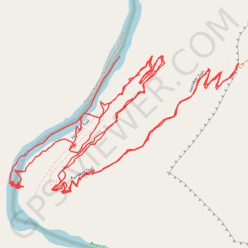
Honaker trail from San Juan River
- Distance: 6.0 mi
- Elevation gain: 3,304 ft
- Maximum elevation: 5,174 ft
- Elevation loss: 3,576 ft
- Minimum elevation: 3,953 ft
- Moving time: 2 h 29 m
- Moving speed: 2.4 mph
- Maximum speed: 16.7 mph
- Total time: 3 h 40 m
- Global speed: 1.6 mph
Interactive trail map
Thank you for supporting this site ❤️
Make a donation
Make a donation
Gear up for your next adventure:
As an Amazon Associate, this site earns from qualifying purchases at no extra cost to you.
Trail profile
- Distance: 6.0 mi
- Elevation gain: 3,304 ft
- Maximum elevation: 5,174 ft
- Elevation loss: 3,576 ft
- Minimum elevation: 3,953 ft
- Moving time: 2 h 29 m
- Moving speed: 2.4 mph
- Maximum speed: 16.7 mph
- Total time: 3 h 40 m
- Global speed: 1.6 mph
Thank you for supporting this site ❤️
Make a donation
Make a donation
Gear up for your next adventure:
As an Amazon Associate, this site earns from qualifying purchases at no extra cost to you.
About this trail
Name: Honaker trail from San Juan River trail, distance, elevation, map, profile, GPS track
Start: Honaker Trail, San Juan County, Utah, United States (37.18535 -109.96130)
End: Honaker Trail, San Juan County, Utah, United States (37.18880 -109.95914)
Coordinates: 37.18360 -109.96442 37.18886 -109.95346
Topography: San Juan County topographic map, elevation, terrain
Thank you for supporting this site ❤️
Make a donation
Make a donation
Gear up for your next adventure:
As an Amazon Associate, this site earns from qualifying purchases at no extra cost to you.