Thank you for supporting this site ❤️
Make a donation
Make a donation
Gear up for your next adventure:
As an Amazon Associate, this site earns from qualifying purchases at no extra cost to you.
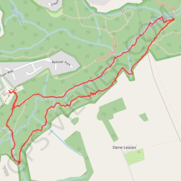
Castle Eden Dene walk
County Durham Walking
- Distance: 2.7 mi
- Elevation gain: 410 ft
- Maximum elevation: 312 ft
- Elevation loss: 413 ft
- Minimum elevation: 141 ft
- Moving time: 1 h 22 m
- Moving speed: 1.9 mph
- Maximum speed: 5.3 mph
- Total time: 1 h 31 m
- Global speed: 1.8 mph
Interactive trail map
Thank you for supporting this site ❤️
Make a donation
Make a donation
Gear up for your next adventure:
As an Amazon Associate, this site earns from qualifying purchases at no extra cost to you.
Trail profile
- Distance: 2.7 mi
- Elevation gain: 410 ft
- Maximum elevation: 312 ft
- Elevation loss: 413 ft
- Minimum elevation: 141 ft
- Moving time: 1 h 22 m
- Moving speed: 1.9 mph
- Maximum speed: 5.3 mph
- Total time: 1 h 31 m
- Global speed: 1.8 mph
Thank you for supporting this site ❤️
Make a donation
Make a donation
Gear up for your next adventure:
As an Amazon Associate, this site earns from qualifying purchases at no extra cost to you.
About this trail
Name: Castle Eden Dene walk trail, distance, elevation, map, profile, GPS track
Coordinates: 54.74288 -1.33736 54.75204 -1.31935
Thank you for supporting this site ❤️
Make a donation
Make a donation
Gear up for your next adventure:
As an Amazon Associate, this site earns from qualifying purchases at no extra cost to you.
Other hiking, mountain biking, running and outdoor activity trails
Click on a trail to view its statistics, map and profile.
Castle Eden Dene walk
United Kingdom > England > County Durham > Peterlee
County Durham Walking
Distance: 2.5 mi • Elevation gain: 367 ft • Maximum elevation: 377 ft