Thank you for supporting this site ❤️
Make a donation
Make a donation
Gear up for your next adventure:
As an Amazon Associate, this site earns from qualifying purchases at no extra cost to you.
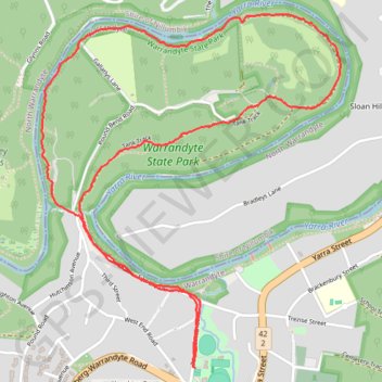
Pound Bend Loop
Warrandyte State Park. Yarra River. #Hiking #Loop #Warrandyte
- Distance: 4.0 mi
- Elevation gain: 341 ft
- Maximum elevation: 276 ft
- Elevation loss: 341 ft
- Minimum elevation: 89 ft
- Moving time: 1 h 7 m
- Moving speed: 3.5 mph
- Maximum speed: 5.1 mph
- Total time: 1 h 8 m
- Global speed: 3.5 mph
Interactive trail map
Thank you for supporting this site ❤️
Make a donation
Make a donation
Gear up for your next adventure:
As an Amazon Associate, this site earns from qualifying purchases at no extra cost to you.
Trail profile
- Distance: 4.0 mi
- Elevation gain: 341 ft
- Maximum elevation: 276 ft
- Elevation loss: 341 ft
- Minimum elevation: 89 ft
- Moving time: 1 h 7 m
- Moving speed: 3.5 mph
- Maximum speed: 5.1 mph
- Total time: 1 h 8 m
- Global speed: 3.5 mph
Thank you for supporting this site ❤️
Make a donation
Make a donation
Gear up for your next adventure:
As an Amazon Associate, this site earns from qualifying purchases at no extra cost to you.
About this trail
Name: Pound Bend Loop trail, distance, elevation, map, profile, GPS track
Coordinates: -37.74560 145.19847 -37.73016 145.21498
Thank you for supporting this site ❤️
Make a donation
Make a donation
Gear up for your next adventure:
As an Amazon Associate, this site earns from qualifying purchases at no extra cost to you.
Other hiking, mountain biking, running and outdoor activity trails
Click on a trail to view its statistics, map and profile.
Tallarook - Eildon - Hurstbridge
Australia > Victoria > Tallarook
#Bike
Distance: 173.2 mi • Elevation gain: 16,066 ft • Maximum elevation: 2,848 ft