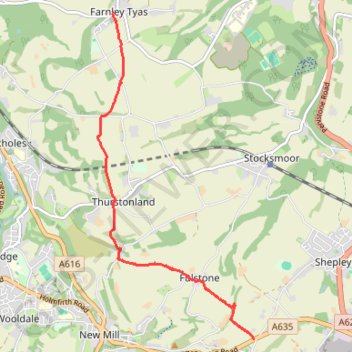
Gate Foot to Farnley Tyas via Thurstonland
Gate Foot - Snowgate Head - Fulstone - Biggin - Top of the Bank - Thurstonland - Top of the Hill - Farnley Tyas
- Distance: 3.6 mi
- Elevation gain: 466 ft
- Maximum elevation: 945 ft
- Elevation loss: 554 ft
- Minimum elevation: 663 ft
- Moving time: 1 h 48 m
- Moving speed: 2.0 mph
- Maximum speed: 3.5 mph
- Total time: 2 h 17 m
- Global speed: 1.6 mph
Interactive trail map
Trail profile
- Distance: 3.6 mi
- Elevation gain: 466 ft
- Maximum elevation: 945 ft
- Elevation loss: 554 ft
- Minimum elevation: 663 ft
- Moving time: 1 h 48 m
- Moving speed: 2.0 mph
- Maximum speed: 3.5 mph
- Total time: 2 h 17 m
- Global speed: 1.6 mph
About this trail
Name: Gate Foot to Farnley Tyas via Thurstonland trail, distance, elevation, map, profile, GPS track
Coordinates: 53.57459 -1.75583 53.61108 -1.72628
Other hiking, mountain biking, running and outdoor activity trails
Click on a trail to view its statistics, map and profile.
Brockholes and Thurstonland Loop
United Kingdom > England > Kirklees > Brockholes > Upper Hagg
Distance: 2.5 mi • Elevation gain: 472 ft • Maximum elevation: 860 ft
Kirklees Way from Gate Foot to Hepworth
United Kingdom > England > Kirklees > Fulstone > Snowgate Head
Snowgate Head - Gate Foot - Jackson Bridge - Hepworth
Distance: 2.9 mi • Elevation gain: 449 ft • Maximum elevation: 1,096 ft
Shepley loop walk
United Kingdom > England > Kirklees > Kirkburton
Distance: 3.3 mi • Elevation gain: 354 ft • Maximum elevation: 830 ft