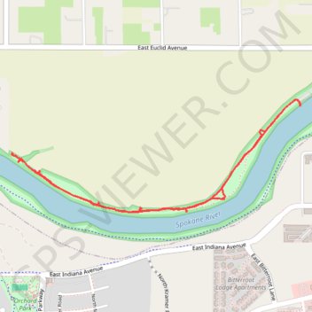
Trails in Harvard Park area along Spokane River near Liberty Lake
- Distance: 2.5 mi
- Elevation gain: 82 ft
- Maximum elevation: 2,028 ft
- Elevation loss: 82 ft
- Minimum elevation: 2,001 ft
- Moving time: 50 m 20 s
- Moving speed: 3.0 mph
- Maximum speed: 3.9 mph
- Total time: 1 h 24 m
- Global speed: 1.8 mph
Interactive trail map
Trail profile
- Distance: 2.5 mi
- Elevation gain: 82 ft
- Maximum elevation: 2,028 ft
- Elevation loss: 82 ft
- Minimum elevation: 2,001 ft
- Moving time: 50 m 20 s
- Moving speed: 3.0 mph
- Maximum speed: 3.9 mph
- Total time: 1 h 24 m
- Global speed: 1.8 mph
About this trail
Name: Trails in Harvard Park area along Spokane River near Liberty Lake trail, distance, elevation, map, profile, GPS track
Coordinates: 47.67828 -117.13244 47.68348 -117.11266
Topography: Spokane County topographic map, elevation, terrain
Other hiking, mountain biking, running and outdoor activity trails
Click on a trail to view its statistics, map and profile.
Part of Spokane River Centennial Trail
United States > Washington > Spokane County > Liberty Lake
Distance: 12.0 mi • Elevation gain: 233 ft • Maximum elevation: 2,077 ft