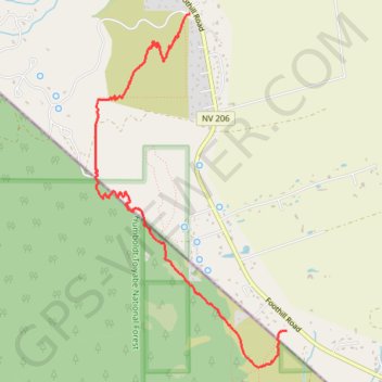
FLJPR Trail
Fay Luther Jobs Peak Ranch Hiking Trail
- Distance: 3.7 mi
- Elevation gain: 673 ft
- Maximum elevation: 5,351 ft
- Elevation loss: 676 ft
- Minimum elevation: 4,823 ft
- Moving time: 1 h 8 m
- Moving speed: 3.3 mph
- Maximum speed: 4.5 mph
- Total time: 1 h 8 m
- Global speed: 3.3 mph
Interactive trail map
Trail profile
- Distance: 3.7 mi
- Elevation gain: 673 ft
- Maximum elevation: 5,351 ft
- Elevation loss: 676 ft
- Minimum elevation: 4,823 ft
- Moving time: 1 h 8 m
- Moving speed: 3.3 mph
- Maximum speed: 4.5 mph
- Total time: 1 h 8 m
- Global speed: 3.3 mph
About this trail
Name: FLJPR Trail trail, distance, elevation, map, profile, GPS track
Start: Fay-Luther Trail Head, Sandy Trail, Douglas County, Nevada, United States (38.87023 -119.81072)
End: Five Creek Road, Sheridan, Douglas County, Nevada, United States (38.89559 -119.82068)
Coordinates: 38.86733 -119.83039 38.89562 -119.81072
Topography: Douglas County topographic map, elevation, terrain
Other hiking, mountain biking, running and outdoor activity trails
Click on a trail to view its statistics, map and profile.
Fay-Luther-Jobs Peak Ranch Trail
United States > Nevada > Douglas County
Distance: 4.0 mi • Elevation gain: 673 ft • Maximum elevation: 5,351 ft