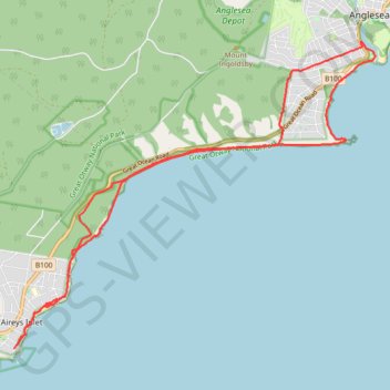
Anglesea - Aireys Inlet
Great Otway National Park. #Hiking #Loop #GreatOtway
- Distance: 15.4 mi
- Elevation gain: 1,516 ft
- Maximum elevation: 325 ft
- Elevation loss: 1,516 ft
- Minimum elevation: 0 ft
- Moving time: 6 h 49 m
- Moving speed: 2.3 mph
- Maximum speed: 24.1 mph
- Total time: 7 h 23 m
- Global speed: 2.1 mph
Interactive trail map
Trail profile
- Distance: 15.4 mi
- Elevation gain: 1,516 ft
- Maximum elevation: 325 ft
- Elevation loss: 1,516 ft
- Minimum elevation: 0 ft
- Moving time: 6 h 49 m
- Moving speed: 2.3 mph
- Maximum speed: 24.1 mph
- Total time: 7 h 23 m
- Global speed: 2.1 mph
About this trail
Name: Anglesea - Aireys Inlet trail, distance, elevation, map, profile, GPS track
Start: Surf Coast Walk, Anglesea, Surf Coast Shire, Victoria, 3230, Australia (-38.41043 144.18742)
End: Surf Coast Walk, Anglesea, Surf Coast Shire, Victoria, 3230, Australia (-38.41019 144.18708)
Coordinates: -38.46708 144.10519 -38.41011 144.19042
Other hiking, mountain biking, running and outdoor activity trails
Click on a trail to view its statistics, map and profile.
Surf Coast Walk
Australia > Victoria > Torquay
Bass Strait. #Hiking
Distance: 21.1 mi • Elevation gain: 1,991 ft • Maximum elevation: 364 ft