Make a donation
Gear up for your next adventure:
As an Amazon Associate, this site earns from qualifying purchases at no extra cost to you.
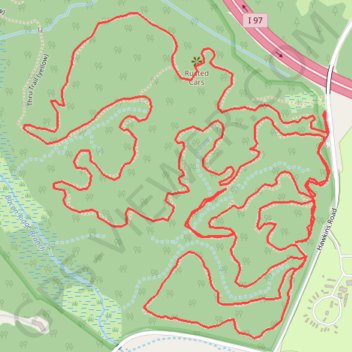
Bacon Ridge Natural Area loop trails
Morning hike
- Distance: 5.0 mi
- Elevation gain: 397 ft
- Maximum elevation: 141 ft
- Elevation loss: 397 ft
- Minimum elevation: 36 ft
- Moving time: 2 h 8 m
- Moving speed: 2.3 mph
- Maximum speed: 5.1 mph
- Total time: 2 h 27 m
- Global speed: 2.0 mph
Interactive trail map
Make a donation
Gear up for your next adventure:
As an Amazon Associate, this site earns from qualifying purchases at no extra cost to you.
Trail profile
- Distance: 5.0 mi
- Elevation gain: 397 ft
- Maximum elevation: 141 ft
- Elevation loss: 397 ft
- Minimum elevation: 36 ft
- Moving time: 2 h 8 m
- Moving speed: 2.3 mph
- Maximum speed: 5.1 mph
- Total time: 2 h 27 m
- Global speed: 2.0 mph
Make a donation
Gear up for your next adventure:
As an Amazon Associate, this site earns from qualifying purchases at no extra cost to you.
About this trail
Name: Bacon Ridge Natural Area loop trails trail, distance, elevation, map, profile, GPS track
Start: Hawkins Road, Anne Arundel County, Maryland, 21140, United States (39.00689 -76.60832)
End: Hawkins Road, Anne Arundel County, Maryland, 21140, United States (39.00685 -76.60832)
Coordinates: 39.00183 -76.61698 39.00906 -76.60822
Topography: Anne Arundel County topographic map, elevation, terrain
Make a donation
Gear up for your next adventure:
As an Amazon Associate, this site earns from qualifying purchases at no extra cost to you.