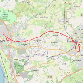
Irvine, Scotland to Kilmarnock and back
Morning Bike Ride
- Distance: 16.9 mi
- Elevation gain: 482 ft
- Maximum elevation: 187 ft
- Elevation loss: 492 ft
- Minimum elevation: 33 ft
- Moving time: 1 h 13 m
- Moving speed: 13.8 mph
- Maximum speed: 24.8 mph
- Total time: 1 h 48 m
- Global speed: 9.4 mph
Interactive trail map
Trail profile
- Distance: 16.9 mi
- Elevation gain: 482 ft
- Maximum elevation: 187 ft
- Elevation loss: 492 ft
- Minimum elevation: 33 ft
- Moving time: 1 h 13 m
- Moving speed: 13.8 mph
- Maximum speed: 24.8 mph
- Total time: 1 h 48 m
- Global speed: 9.4 mph
About this trail
Name: Irvine, Scotland to Kilmarnock and back trail, distance, elevation, map, profile, GPS track
Start: Galt Avenue, Irvine, North Ayrshire, Scotland, KA12 0NW, United Kingdom (55.61828 -4.65577)
End: 64, Oaklands Avenue, Irvine, North Ayrshire, Scotland, KA12 0SE, United Kingdom (55.62427 -4.66376)
Coordinates: 55.60106 -4.66376 55.62562 -4.49641
Other hiking, mountain biking, running and outdoor activity trails
Click on a trail to view its statistics, map and profile.
Irvine, Scotland to Troon and back
United Kingdom > Scotland > North Ayrshire > Irvine
Evening Bike Ride
Distance: 21.0 mi • Elevation gain: 1,257 ft • Maximum elevation: 420 ft
Irvine, Scotland to Largs and back
United Kingdom > Scotland > North Ayrshire > Irvine
Morning Bike Ride
Distance: 41.6 mi • Elevation gain: 1,063 ft • Maximum elevation: 115 ft
Irvine, Scotland to Eglinton Country Park and back
United Kingdom > Scotland > North Ayrshire > Irvine
Loop Bike
Distance: 8.5 mi • Elevation gain: 220 ft • Maximum elevation: 105 ft
Irvine, Scotland to Barassie Beach and back
United Kingdom > Scotland > North Ayrshire > Irvine
Bike
Distance: 13.5 mi • Elevation gain: 282 ft • Maximum elevation: 49 ft
Shewalton Wood Wildlife Reserve & Barassie Beach
United Kingdom > Scotland > North Ayrshire > Irvine
Bike
Distance: 16.2 mi • Elevation gain: 302 ft • Maximum elevation: 59 ft
Irvine, Scotland to Stonehouse and back
United Kingdom > Scotland > North Ayrshire > Irvine
Stonehouse, South Lanarkshire, Bike, Loop
Distance: 69.5 mi • Elevation gain: 3,668 ft • Maximum elevation: 991 ft
Irvine, Scotland to West Kilbride and back
United Kingdom > Scotland > North Ayrshire > Irvine
Afternoon Bike Ride
Distance: 25.0 mi • Elevation gain: 928 ft • Maximum elevation: 331 ft
Irvine, Scotland to Kilmarnock and back
United Kingdom > Scotland > North Ayrshire > Irvine
Bike
Distance: 19.9 mi • Elevation gain: 630 ft • Maximum elevation: 217 ft
Irvine, Scotland to Greenan Castle and back
United Kingdom > Scotland > North Ayrshire > Irvine
Bike
Distance: 36.9 mi • Elevation gain: 778 ft • Maximum elevation: 89 ft
Irvine, Scotland to Troon and back
United Kingdom > Scotland > North Ayrshire > Irvine
Afternoon Loop Bike Ride
Distance: 20.9 mi • Elevation gain: 1,027 ft • Maximum elevation: 423 ft
Irvine, Scotland to Stevenston and back
United Kingdom > Scotland > North Ayrshire > Irvine
Afternoon Bike Ride
Distance: 11.7 mi • Elevation gain: 233 ft • Maximum elevation: 92 ft
Irvine, Scotland to Kilmarnock and back
United Kingdom > Scotland > North Ayrshire > Irvine
Afternoon Bike Ride
Distance: 21.2 mi • Elevation gain: 712 ft • Maximum elevation: 299 ft
Irvine, Scotland to Kilmarnock and back
United Kingdom > Scotland > North Ayrshire > Irvine
Evening Bike Ride
Distance: 26.1 mi • Elevation gain: 850 ft • Maximum elevation: 302 ft
Afternoon at the Beach, Irvine, Scotland
United Kingdom > Scotland > North Ayrshire > Irvine
Distance: 4.4 mi • Elevation gain: 105 ft • Maximum elevation: 52 ft
Irvine, Scotland to Ardrossan and back
United Kingdom > Scotland > North Ayrshire > Irvine
Bike
Distance: 19.4 mi • Elevation gain: 377 ft • Maximum elevation: 72 ft
Irvine, Scotland to Dalry and back
United Kingdom > Scotland > North Ayrshire > Irvine
Evening Loop Bike Ride
Distance: 17.9 mi • Elevation gain: 899 ft • Maximum elevation: 348 ft
Irvine, Scotland to Dalry and back
United Kingdom > Scotland > North Ayrshire > Irvine
Bike
Distance: 16.6 mi • Elevation gain: 833 ft • Maximum elevation: 230 ft
Irvine, Scotland to Ayr and back
United Kingdom > Scotland > North Ayrshire > Irvine
Bike
Distance: 32.9 mi • Elevation gain: 594 ft • Maximum elevation: 52 ft
Irvine, Scotland to Ayr and back
United Kingdom > Scotland > North Ayrshire > Irvine
Bike
Distance: 28.7 mi • Elevation gain: 443 ft • Maximum elevation: 52 ft
Sunset at the Beach
United Kingdom > Scotland > North Ayrshire > Irvine
Bike
Distance: 5.1 mi • Elevation gain: 92 ft • Maximum elevation: 49 ft
Evening Gravel Scouting
United Kingdom > Scotland > North Ayrshire > Irvine
Distance: 14.1 mi • Elevation gain: 266 ft • Maximum elevation: 62 ft
Afternoon at the Beach
United Kingdom > Scotland > North Ayrshire > Irvine
Distance: 4.7 mi • Elevation gain: 115 ft • Maximum elevation: 52 ft
Irvine, Scotland
United Kingdom > Scotland > North Ayrshire > Irvine
Evening Loop Bike Ride
Distance: 21.3 mi • Elevation gain: 292 ft • Maximum elevation: 49 ft
Irvine, Scotland
United Kingdom > Scotland > North Ayrshire > Irvine
Afternoon Loop Walk
Distance: 3.8 mi • Elevation gain: 89 ft • Maximum elevation: 52 ft
Irvine Loop Bike
United Kingdom > Scotland > North Ayrshire > Irvine
Afternoon Ride
Distance: 9.0 mi • Elevation gain: 148 ft • Maximum elevation: 52 ft
Escort to Troon
United Kingdom > Scotland > North Ayrshire > Irvine
Bike
Distance: 21.7 mi • Elevation gain: 410 ft • Maximum elevation: 62 ft
Beach Gravel
United Kingdom > Scotland > North Ayrshire > Irvine
Distance: 7.6 mi • Elevation gain: 184 ft • Maximum elevation: 52 ft
Kilmarnock, Scotland
United Kingdom > Scotland > East Ayrshire > Kilmarnock
Afternoon Walk
Distance: 1.2 mi • Elevation gain: 23 ft • Maximum elevation: 115 ft
Irvine, Scotland
United Kingdom > Scotland > North Ayrshire > Irvine
Afternoon Walk
Distance: 0.9 mi • Elevation gain: 30 ft • Maximum elevation: 52 ft