Make a donation
Gear up for your next adventure:
As an Amazon Associate, this site earns from qualifying purchases at no extra cost to you.
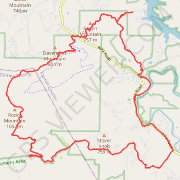
Stanley Gap MTB Loop
Mountain Bike loop via Long Branch Loop, Toccoa River, Stanley Creek, Rocky Mountain and Green Mountain in Chattahoochee-Oconee National Forest (Blue Ridge District). #MTB #Loop #Mountain #Forest #River #Nature
- Distance: 15.5 mi
- Elevation gain: 3,087 ft
- Maximum elevation: 3,333 ft
- Elevation loss: 3,100 ft
- Minimum elevation: 1,729 ft
- Moving time: 2 h 54 m
- Moving speed: 5.3 mph
- Maximum speed: 34.3 mph
- Total time: 3 h 57 m
- Global speed: 3.9 mph
Interactive trail map
Make a donation
Gear up for your next adventure:
As an Amazon Associate, this site earns from qualifying purchases at no extra cost to you.
Trail profile
- Distance: 15.5 mi
- Elevation gain: 3,087 ft
- Maximum elevation: 3,333 ft
- Elevation loss: 3,100 ft
- Minimum elevation: 1,729 ft
- Moving time: 2 h 54 m
- Moving speed: 5.3 mph
- Maximum speed: 34.3 mph
- Total time: 3 h 57 m
- Global speed: 3.9 mph
Make a donation
Gear up for your next adventure:
As an Amazon Associate, this site earns from qualifying purchases at no extra cost to you.
About this trail
Name: Stanley Gap MTB Loop trail, distance, elevation, map, profile, GPS track
Start: Fannin County, Georgia, 30513, United States (34.82380 -84.27962)
End: Fannin County, Georgia, 30513, United States (34.82392 -84.27933)
Coordinates: 34.77781 -84.32460 34.82392 -84.26472
Topography: Fannin County topographic map, elevation, terrain
Make a donation
Gear up for your next adventure:
As an Amazon Associate, this site earns from qualifying purchases at no extra cost to you.