Make a donation
Gear up for your next adventure:
As an Amazon Associate, this site earns from qualifying purchases at no extra cost to you.
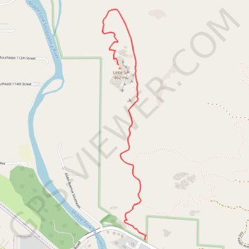
Little Si
Interactive trail map
Make a donation
Gear up for your next adventure:
As an Amazon Associate, this site earns from qualifying purchases at no extra cost to you.
Trail profile
- Distance: 3.6 mi
- Elevation gain: 1,056 ft
- Maximum elevation: 1,427 ft
- Elevation loss: 1,050 ft
- Minimum elevation: 512 ft
Make a donation
Gear up for your next adventure:
As an Amazon Associate, this site earns from qualifying purchases at no extra cost to you.
About this trail
Name: Little Si trail, distance, elevation, map, profile, GPS track
Coordinates: 47.48675 -121.75777 47.50276 -121.75329
Topography: King County topographic map, elevation, terrain
Make a donation
Gear up for your next adventure:
As an Amazon Associate, this site earns from qualifying purchases at no extra cost to you.
Other hiking, mountain biking, running and outdoor activity trails
Click on a trail to view its statistics, map and profile.
Northern part of the Pacific Crest Trail (PCT)
United States > Oregon > Klamath County
Hike on the Pacific Crest National Scenic Trail from Crater Lake to Canada Border through Oregon and Washington along the Sierra Nevada and Cascade mountain ranges. #Hiking #Mountain #SierraNevada #Cascade #Nature #Forest #Park #PCT
Distance: 744.6 mi • Elevation gain: 145,367 ft • Maximum elevation: 7,569 ft
Old Mount Si Trail
United States > Washington > King County > North Bend
Distance: 8.3 mi • Elevation gain: 3,560 ft • Maximum elevation: 3,783 ft
Track (8/12/23, 7:47:57AM)
United States > Washington > King County
Distance: 36.0 mi • Elevation gain: 12,182 ft • Maximum elevation: 4,606 ft