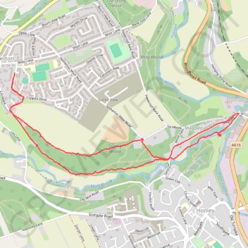
Netherton and Magdale loop walk via Spring Wood and Magdale Dam
- Distance: 3.1 mi
- Elevation gain: 361 ft
- Maximum elevation: 574 ft
- Elevation loss: 361 ft
- Minimum elevation: 312 ft
- Moving time: 1 h 54 m
- Moving speed: 1.6 mph
- Maximum speed: 3.3 mph
- Total time: 3 h 58 s
- Global speed: 1.0 mph
Interactive trail map
Trail profile
- Distance: 3.1 mi
- Elevation gain: 361 ft
- Maximum elevation: 574 ft
- Elevation loss: 361 ft
- Minimum elevation: 312 ft
- Moving time: 1 h 54 m
- Moving speed: 1.6 mph
- Maximum speed: 3.3 mph
- Total time: 3 h 58 s
- Global speed: 1.0 mph
About this trail
Name: Netherton and Magdale loop walk via Spring Wood and Magdale Dam trail, distance, elevation, map, profile, GPS track
Coordinates: 53.60676 -1.81330 53.61332 -1.78833
Other hiking, mountain biking, running and outdoor activity trails
Click on a trail to view its statistics, map and profile.
Netherton woods circular
United Kingdom > England > Kirklees > Netherton
Distance: 3.9 mi • Elevation gain: 482 ft • Maximum elevation: 669 ft