Make a donation
Gear up for your next adventure:
As an Amazon Associate, this site earns from qualifying purchases at no extra cost to you.
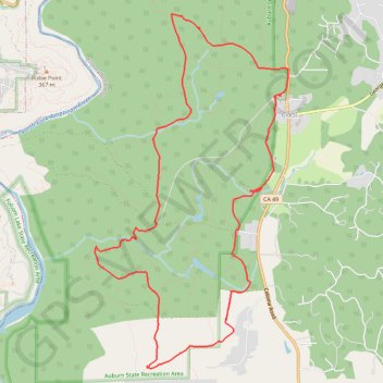
Olmstead Loop Trail
Mountain Bike loop in Auburn State Recreation Area. #MTB #Loop #Forest #Nature
- Distance: 9.3 mi
- Elevation gain: 1,010 ft
- Maximum elevation: 1,627 ft
- Elevation loss: 1,010 ft
- Minimum elevation: 1,250 ft
- Moving time: 1 h 32 m
- Moving speed: 6.0 mph
- Maximum speed: 18.3 mph
- Total time: 1 h 55 m
- Global speed: 4.8 mph
Interactive trail map
Make a donation
Gear up for your next adventure:
As an Amazon Associate, this site earns from qualifying purchases at no extra cost to you.
Trail profile
- Distance: 9.3 mi
- Elevation gain: 1,010 ft
- Maximum elevation: 1,627 ft
- Elevation loss: 1,010 ft
- Minimum elevation: 1,250 ft
- Moving time: 1 h 32 m
- Moving speed: 6.0 mph
- Maximum speed: 18.3 mph
- Total time: 1 h 55 m
- Global speed: 4.8 mph
Make a donation
Gear up for your next adventure:
As an Amazon Associate, this site earns from qualifying purchases at no extra cost to you.
About this trail
Name: Olmstead Loop Trail trail, distance, elevation, map, profile, GPS track
Start: Olmstead Loop Trail, Cool, El Dorado County, California, 95614, United States (38.88923 -121.01723)
End: Olmstead Loop Trail, Cool, El Dorado County, California, 95614, United States (38.88925 -121.01737)
Coordinates: 38.85715 -121.04513 38.89879 -121.01597
Topography: El Dorado County topographic map, elevation, terrain
Make a donation
Gear up for your next adventure:
As an Amazon Associate, this site earns from qualifying purchases at no extra cost to you.