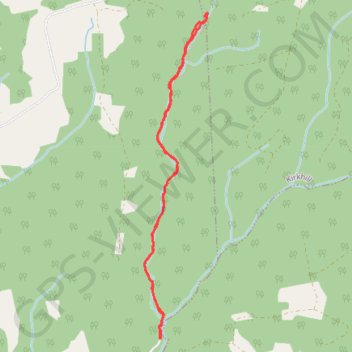
Thank you for supporting this site ❤️
Make a donation
Make a donation
Gear up for your next adventure:
As an Amazon Associate, this site earns from qualifying purchases at no extra cost to you.
Ward Falls Trail
Hiking, Wilderness, Backcountry, waterfall
- Distance: 4.0 mi
- Elevation gain: 413 ft
- Maximum elevation: 371 ft
- Elevation loss: 413 ft
- Minimum elevation: 115 ft
- Moving time: 1 h 39 m
- Moving speed: 2.4 mph
- Maximum speed: 4.5 mph
- Total time: 2 h 22 m
- Global speed: 1.7 mph
Interactive trail map
Thank you for supporting this site ❤️
Make a donation
Make a donation
Gear up for your next adventure:
As an Amazon Associate, this site earns from qualifying purchases at no extra cost to you.
Trail profile
- Distance: 4.0 mi
- Elevation gain: 413 ft
- Maximum elevation: 371 ft
- Elevation loss: 413 ft
- Minimum elevation: 115 ft
- Moving time: 1 h 39 m
- Moving speed: 2.4 mph
- Maximum speed: 4.5 mph
- Total time: 2 h 22 m
- Global speed: 1.7 mph
Thank you for supporting this site ❤️
Make a donation
Make a donation
Gear up for your next adventure:
As an Amazon Associate, this site earns from qualifying purchases at no extra cost to you.
About this trail
Name: Ward Falls Trail trail, distance, elevation, map, profile, GPS track
Coordinates: 45.42320 -64.42626 45.44745 -64.41943
Thank you for supporting this site ❤️
Make a donation
Make a donation
Gear up for your next adventure:
As an Amazon Associate, this site earns from qualifying purchases at no extra cost to you.