Wildwood river
Larger Wildwood Park Loop
- Distance: 2.7 mi
- Elevation gain: 36 ft
- Maximum elevation: 26 ft
- Elevation loss: 36 ft
- Minimum elevation: 7 ft
- Moving time: 51 m 52 s
- Moving speed: 3.2 mph
- Maximum speed: 9.5 mph
- Total time: 54 m 2 s
- Global speed: 3.0 mph
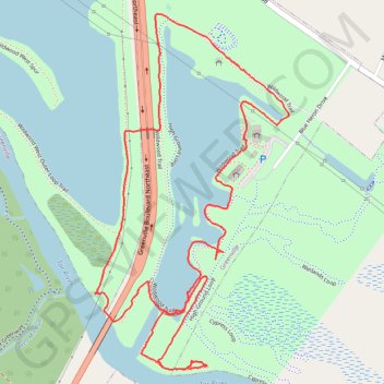
Interactive trail map
Trail profile
- Distance: 2.7 mi
- Elevation gain: 36 ft
- Maximum elevation: 26 ft
- Elevation loss: 36 ft
- Minimum elevation: 7 ft
- Moving time: 51 m 52 s
- Moving speed: 3.2 mph
- Maximum speed: 9.5 mph
- Total time: 54 m 2 s
- Global speed: 3.0 mph
About this trail
Name: Wildwood river trail, distance, elevation, map, profile, GPS track
Start: Wildwood Trail, Greenville, Pitt County, North Carolina, 27858, United States (35.61286 -77.32509)
End: Wildwood Trail, Greenville, Pitt County, North Carolina, 27858, United States (35.61285 -77.32506)
Coordinates: 35.60671 -77.33016 35.61668 -77.32346
Topography: Greenville topographic map, elevation, terrain
Other hiking, mountain biking, running and outdoor activity trails
Click on a trail to view its statistics, map and profile.
Wildwood West Outer Loop - Northern Half
United States > North Carolina > Pitt County > Greenville
Distance: 4.8 mi • Elevation gain: 59 ft • Maximum elevation: 30 ft
Wildwood West Outer Loop - Southern Half
United States > North Carolina > Pitt County > Greenville
Distance: 3.6 mi • Elevation gain: 66 ft • Maximum elevation: 26 ft
Wildwood Park Loop
United States > North Carolina > Pitt County > Greenville
Distance: 4.5 mi • Elevation gain: 85 ft • Maximum elevation: 30 ft
Wildwood Boardwalk Loop
United States > North Carolina > Pitt County > Greenville
Distance: 1.5 mi • Elevation gain: 26 ft • Maximum elevation: 33 ft