Make a donation
Gear up for your next adventure:
As an Amazon Associate, this site earns from qualifying purchases at no extra cost to you.
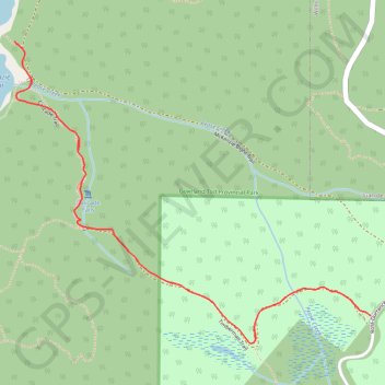
McKenzie Bight - Cascade Falls
Gowlland Tod Provincial Park. #Hiking #GowllandTod
- Distance: 2.1 mi
- Elevation gain: 525 ft
- Maximum elevation: 492 ft
- Elevation loss: 525 ft
- Minimum elevation: 36 ft
Interactive trail map
Make a donation
Gear up for your next adventure:
As an Amazon Associate, this site earns from qualifying purchases at no extra cost to you.
Trail profile
- Distance: 2.1 mi
- Elevation gain: 525 ft
- Maximum elevation: 492 ft
- Elevation loss: 525 ft
- Minimum elevation: 36 ft
Make a donation
Gear up for your next adventure:
As an Amazon Associate, this site earns from qualifying purchases at no extra cost to you.
About this trail
Name: McKenzie Bight - Cascade Falls trail, distance, elevation, map, profile, GPS track
Coordinates: 48.54793 -123.50509 48.55519 -123.49217
Make a donation
Gear up for your next adventure:
As an Amazon Associate, this site earns from qualifying purchases at no extra cost to you.
Other hiking, mountain biking, running and outdoor activity trails
Click on a trail to view its statistics, map and profile.
Mount Work - Mount Stewart - Thetis Lake
Canada > British Columbia > Capital Regional District > Highlands
Distance: 12.6 mi • Elevation gain: 2,287 ft • Maximum elevation: 1,430 ft
BBF loop to the Skydeck in Nanaimo
Canada > British Columbia > Cowichan Valley Regional District > Area A (Mill Bay / Malahat) > Mill Bay
BBF loop to the Skydeck
Distance: 201.0 mi • Elevation gain: 20,413 ft • Maximum elevation: 2,316 ft
Make a donation
Gear up for your next adventure:
As an Amazon Associate, this site earns from qualifying purchases at no extra cost to you.