Thank you for supporting this site ❤️
Make a donation
Make a donation
Gear up for your next adventure:
As an Amazon Associate, this site earns from qualifying purchases at no extra cost to you.
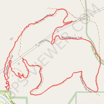
McCosker Loop Trail
Sibley Volcanic Regional Preserve
- Distance: 2.6 mi
- Elevation gain: 531 ft
- Maximum elevation: 1,220 ft
- Elevation loss: 528 ft
- Minimum elevation: 774 ft
- Moving time: 1 h 6 m
- Moving speed: 2.4 mph
- Maximum speed: 9.2 mph
- Total time: 1 h 12 m
- Global speed: 2.2 mph
Interactive trail map
Thank you for supporting this site ❤️
Make a donation
Make a donation
Gear up for your next adventure:
As an Amazon Associate, this site earns from qualifying purchases at no extra cost to you.
Trail profile
- Distance: 2.6 mi
- Elevation gain: 531 ft
- Maximum elevation: 1,220 ft
- Elevation loss: 528 ft
- Minimum elevation: 774 ft
- Moving time: 1 h 6 m
- Moving speed: 2.4 mph
- Maximum speed: 9.2 mph
- Total time: 1 h 12 m
- Global speed: 2.2 mph
Thank you for supporting this site ❤️
Make a donation
Make a donation
Gear up for your next adventure:
As an Amazon Associate, this site earns from qualifying purchases at no extra cost to you.
About this trail
Name: McCosker Loop Trail trail, distance, elevation, map, profile, GPS track
Coordinates: 37.83965 -122.18152 37.84565 -122.17304
Topography: Contra Costa County topographic map, elevation, terrain
Thank you for supporting this site ❤️
Make a donation
Make a donation
Gear up for your next adventure:
As an Amazon Associate, this site earns from qualifying purchases at no extra cost to you.