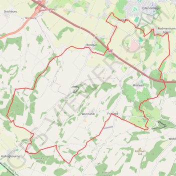
Hollingbourne Hill Loop
- Distance: 19.5 mi
- Elevation gain: 1,280 ft
- Maximum elevation: 650 ft
- Elevation loss: 1,280 ft
- Minimum elevation: 118 ft
Interactive trail map
Trail profile
- Distance: 19.5 mi
- Elevation gain: 1,280 ft
- Maximum elevation: 650 ft
- Elevation loss: 1,280 ft
- Minimum elevation: 118 ft
About this trail
Name: Hollingbourne Hill Loop trail, distance, elevation, map, profile, GPS track
Coordinates: 51.26251 0.63895 51.32662 0.74965
Other hiking, mountain biking, running and outdoor activity trails
Click on a trail to view its statistics, map and profile.
Rodmersham to Frinsted Loop
United Kingdom > England > Kent > Borough of Swale > Rodmersham Green
Distance: 11.9 mi • Elevation gain: 945 ft • Maximum elevation: 522 ft
Doddington 10 mile loop
United Kingdom > England > Kent > Borough of Swale > Rodmersham Green
Distance: 10.1 mi • Elevation gain: 650 ft • Maximum elevation: 358 ft
Bottom Pond Loop
United Kingdom > England > Kent > Borough of Swale > Rodmersham Green
Distance: 9.6 mi • Elevation gain: 745 ft • Maximum elevation: 374 ft
High Wood Loop
United Kingdom > England > Kent > Borough of Swale > Rodmersham Green
Distance: 10.5 mi • Elevation gain: 643 ft • Maximum elevation: 466 ft
Borden loop
United Kingdom > England > Kent > Borough of Swale > Rodmersham Green
Distance: 7.8 mi • Elevation gain: 410 ft • Maximum elevation: 259 ft