Sun Valley for a few tweaks
Lunch Ride
- Distance: 7.8 mi
- Elevation gain: 184 ft
- Maximum elevation: 830 ft
- Elevation loss: 184 ft
- Minimum elevation: 787 ft
- Moving time: 42 m 21 s
- Moving speed: 11.1 mph
- Maximum speed: 17.1 mph
- Total time: 44 m 20 s
- Global speed: 10.6 mph
Interactive trail map
Trail profile
- Distance: 7.8 mi
- Elevation gain: 184 ft
- Maximum elevation: 830 ft
- Elevation loss: 184 ft
- Minimum elevation: 787 ft
- Moving time: 42 m 21 s
- Moving speed: 11.1 mph
- Maximum speed: 17.1 mph
- Total time: 44 m 20 s
- Global speed: 10.6 mph
About this trail
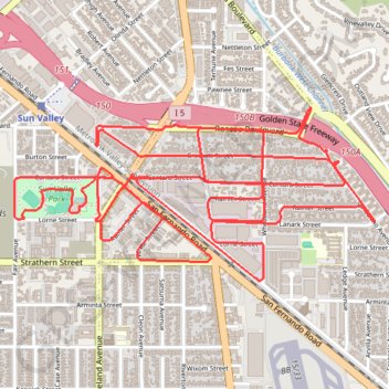
Name: Sun Valley for a few tweaks trail, distance, elevation, map, profile, GPS track
Coordinates: 34.21490 -118.37467 34.22230 -118.35604
Topography: Los Angeles topographic map, elevation, terrain
Other hiking, mountain biking, running and outdoor activity trails
Click on a trail to view its statistics, map and profile.
Verdugo Mountains Full Ridge
United States > California > Los Angeles County > Los Angeles
Hike on the Verdugo Mountains via Village Avenue Trail, La Tuna Peak, Chandler Mtrwy, Boy Scout Camp, Verdugo Motorway, Verdugo Crest Trail, Tree of Life, Wildhos Saddle, Verdugo Peak, Mesa Lila Road, Mount Thom and Las Flores Motorway. #Hiking #Mountain #Nature #Forest #Park
Distance: 14.5 mi • Elevation gain: 3,852 ft • Maximum elevation: 3,104 ft