Thank you for supporting this site ❤️
Make a donation
Make a donation
Gear up for your next adventure:
As an Amazon Associate, this site earns from qualifying purchases at no extra cost to you.
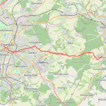
Biking#4
- Distance: 8.1 mi
- Elevation gain: 810 ft
- Maximum elevation: 1,532 ft
- Elevation loss: 814 ft
- Minimum elevation: 984 ft
- Moving time: 42 m 2 s
- Moving speed: 11.5 mph
- Maximum speed: 34.4 mph
- Total time: 42 m 2 s
- Global speed: 11.5 mph
Interactive trail map
Thank you for supporting this site ❤️
Make a donation
Make a donation
Gear up for your next adventure:
As an Amazon Associate, this site earns from qualifying purchases at no extra cost to you.
Trail profile
- Distance: 8.1 mi
- Elevation gain: 810 ft
- Maximum elevation: 1,532 ft
- Elevation loss: 814 ft
- Minimum elevation: 984 ft
- Moving time: 42 m 2 s
- Moving speed: 11.5 mph
- Maximum speed: 34.4 mph
- Total time: 42 m 2 s
- Global speed: 11.5 mph
Thank you for supporting this site ❤️
Make a donation
Make a donation
Gear up for your next adventure:
As an Amazon Associate, this site earns from qualifying purchases at no extra cost to you.
About this trail
Name: Biking#4 trail, distance, elevation, map, profile, GPS track
End: 8, Hohe Straße, Kaßberg, Chemnitz, Saxony, 09112, Germany (50.83061 12.91345)
Coordinates: 50.81640 12.91345 50.83099 13.07477
Thank you for supporting this site ❤️
Make a donation
Make a donation
Gear up for your next adventure:
As an Amazon Associate, this site earns from qualifying purchases at no extra cost to you.