Thank you for supporting this site ❤️
Make a donation
Make a donation
Gear up for your next adventure:
As an Amazon Associate, this site earns from qualifying purchases at no extra cost to you.
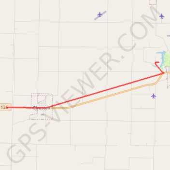
2023-10-21T17:27:28.973471
- Distance: 7.7 mi
- Elevation gain: 121 ft
- Maximum elevation: 692 ft
- Elevation loss: 105 ft
- Minimum elevation: 650 ft
- Moving time: 9 m 59 s
- Moving speed: 46.2 mph
- Maximum speed: 14.7 mph
- Total time: 9 m 59 s
- Global speed: 46.2 mph
Interactive trail map
Thank you for supporting this site ❤️
Make a donation
Make a donation
Gear up for your next adventure:
As an Amazon Associate, this site earns from qualifying purchases at no extra cost to you.
Trail profile
- Distance: 7.7 mi
- Elevation gain: 121 ft
- Maximum elevation: 692 ft
- Elevation loss: 105 ft
- Minimum elevation: 650 ft
- Moving time: 9 m 59 s
- Moving speed: 46.2 mph
- Maximum speed: 14.7 mph
- Total time: 9 m 59 s
- Global speed: 46.2 mph
Thank you for supporting this site ❤️
Make a donation
Make a donation
Gear up for your next adventure:
As an Amazon Associate, this site earns from qualifying purchases at no extra cost to you.
About this trail
Name: 2023-10-21T17:27:28.973471 trail, distance, elevation, map, profile, GPS track
Start: 1173, US Highway 136, Hamilton, Hancock County, Illinois, 62379, United States (40.39537 -91.27745)
End: Hancock County, Illinois, 62336, United States (40.42244 -91.15672)
Coordinates: 40.39493 -91.27745 40.42253 -91.15290
Topography: Hancock County topographic map, elevation, terrain
Thank you for supporting this site ❤️
Make a donation
Make a donation
Gear up for your next adventure:
As an Amazon Associate, this site earns from qualifying purchases at no extra cost to you.