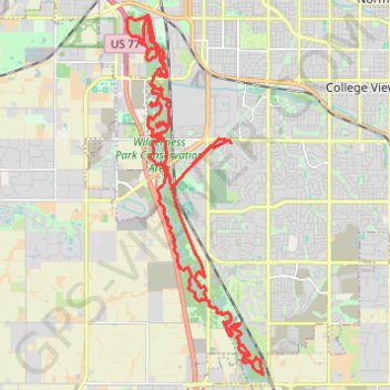
Wildereness Park bike trails
- Distance: 26.2 mi
- Elevation gain: 466 ft
- Maximum elevation: 1,257 ft
- Elevation loss: 466 ft
- Minimum elevation: 1,148 ft
- Moving time: 1 h 53 m
- Moving speed: 13.9 mph
- Maximum speed: 25.9 mph
- Total time: 2 h 29 s
- Global speed: 13.0 mph
Interactive trail map
Trail profile
- Distance: 26.2 mi
- Elevation gain: 466 ft
- Maximum elevation: 1,257 ft
- Elevation loss: 466 ft
- Minimum elevation: 1,148 ft
- Moving time: 1 h 53 m
- Moving speed: 13.9 mph
- Maximum speed: 25.9 mph
- Total time: 2 h 29 s
- Global speed: 13.0 mph
About this trail
Name: Wildereness Park bike trails trail, distance, elevation, map, profile, GPS track
Coordinates: 40.69931 -96.72676 40.78521 -96.68396
Topography: Lincoln topographic map, elevation, terrain
Other hiking, mountain biking, running and outdoor activity trails
Click on a trail to view its statistics, map and profile.
Wilderness park bike trails
United States > Nebraska > Lancaster County > Lincoln
Distance: 23.6 mi • Elevation gain: 417 ft • Maximum elevation: 1,257 ft