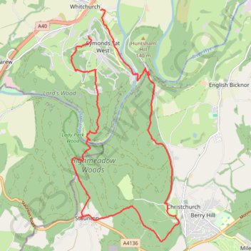
Highmeadow Woods loop from Whitchurch
- Distance: 10.6 mi
- Elevation gain: 1,480 ft
- Maximum elevation: 735 ft
- Elevation loss: 1,837 ft
- Minimum elevation: 66 ft
- Moving time: 4 h 28 m
- Moving speed: 2.4 mph
- Maximum speed: 18.6 mph
- Total time: 6 h 41 m
- Global speed: 1.6 mph
Interactive trail map
Trail profile
- Distance: 10.6 mi
- Elevation gain: 1,480 ft
- Maximum elevation: 735 ft
- Elevation loss: 1,837 ft
- Minimum elevation: 66 ft
- Moving time: 4 h 28 m
- Moving speed: 2.4 mph
- Maximum speed: 18.6 mph
- Total time: 6 h 41 m
- Global speed: 1.6 mph
About this trail
Name: Highmeadow Woods loop from Whitchurch trail, distance, elevation, map, profile, GPS track
Coordinates: 51.80566 -2.66056 51.85381 -2.62437
Other hiking, mountain biking, running and outdoor activity trails
Click on a trail to view its statistics, map and profile.
Blaze the Biblins
United Kingdom > Wales > Monmouthshire > Ross-on-Wye
Blaze the Biblins, trail race by Monross Trailblazers
Distance: 5.7 mi • Elevation gain: 889 ft • Maximum elevation: 505 ft
Dean2023-311
United Kingdom > England > Oxfordshire > Oxford
Distance: 192.8 mi • Elevation gain: 11,043 ft • Maximum elevation: 951 ft