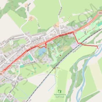
Wildcat Trail Newtonmore
- Distance: 1.1 mi
- Elevation gain: 23 ft
- Maximum elevation: 817 ft
- Elevation loss: 79 ft
- Minimum elevation: 758 ft
- Moving time: 27 m 13 s
- Moving speed: 2.4 mph
- Maximum speed: 7.2 mph
- Total time: 31 m 6 s
- Global speed: 2.1 mph
Interactive trail map
Trail profile
- Distance: 1.1 mi
- Elevation gain: 23 ft
- Maximum elevation: 817 ft
- Elevation loss: 79 ft
- Minimum elevation: 758 ft
- Moving time: 27 m 13 s
- Moving speed: 2.4 mph
- Maximum speed: 7.2 mph
- Total time: 31 m 6 s
- Global speed: 2.1 mph
About this trail
Name: Wildcat Trail Newtonmore trail, distance, elevation, map, profile, GPS track
End: The Wildcat Trail, Newtonmore, Highland, Scotland, PH21 1NR, United Kingdom (57.06733 -4.10021)
Coordinates: 57.06469 -4.12119 57.06934 -4.10021