Make a donation
Gear up for your next adventure:
As an Amazon Associate, this site earns from qualifying purchases at no extra cost to you.
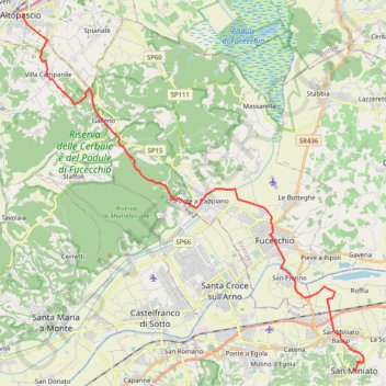
Tappa-29-da-altopascio-san-miniato
- Distance: 18.0 mi
- Elevation gain: 1,161 ft
- Maximum elevation: 482 ft
- Elevation loss: 748 ft
- Minimum elevation: 39 ft
Interactive trail map
Make a donation
Gear up for your next adventure:
As an Amazon Associate, this site earns from qualifying purchases at no extra cost to you.
Trail profile
- Distance: 18.0 mi
- Elevation gain: 1,161 ft
- Maximum elevation: 482 ft
- Elevation loss: 748 ft
- Minimum elevation: 39 ft
Make a donation
Gear up for your next adventure:
As an Amazon Associate, this site earns from qualifying purchases at no extra cost to you.
About this trail
Name: Tappa-29-da-altopascio-san-miniato trail, distance, elevation, map, profile, GPS track
Start: Piazza Giuseppe Garibaldi, Altopascio, Lucca, Tuscany, 55011, Italy (43.81512 10.67532)
End: Gargozzi, La Scala, San Miniato, Pisa, Tuscany, 56028, Italy (43.67935 10.85148)
Coordinates: 43.67933 10.67532 43.81512 10.85517
Make a donation
Gear up for your next adventure:
As an Amazon Associate, this site earns from qualifying purchases at no extra cost to you.
Other hiking, mountain biking, running and outdoor activity trails
Click on a trail to view its statistics, map and profile.
1 LUCENA - MONTPELLIER
Distance: 1,842.0 mi • Elevation gain: 96,785 ft • Maximum elevation: 3,438 ft
VFS - IT29 - SanMiniato - GambassiTerme.gpx (1)
Italy > Tuscany > Pisa > San Miniato > La Scala > Gargozzi
Distance: 14.9 mi • Elevation gain: 2,379 ft • Maximum elevation: 1,040 ft