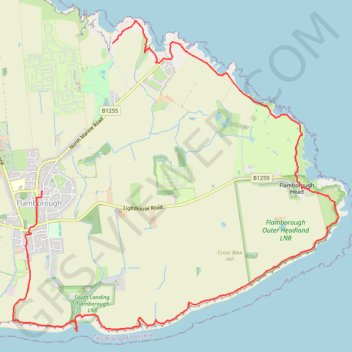
Flamborough Loop
- Distance: 6.5 mi
- Elevation gain: 1,014 ft
- Maximum elevation: 157 ft
- Elevation loss: 951 ft
- Minimum elevation: 0 ft
- Moving time: 2 h 30 m
- Moving speed: 2.6 mph
- Maximum speed: 4.0 mph
- Total time: 2 h 49 m
- Global speed: 2.3 mph
Interactive trail map
Trail profile
- Distance: 6.5 mi
- Elevation gain: 1,014 ft
- Maximum elevation: 157 ft
- Elevation loss: 951 ft
- Minimum elevation: 0 ft
- Moving time: 2 h 30 m
- Moving speed: 2.6 mph
- Maximum speed: 4.0 mph
- Total time: 2 h 49 m
- Global speed: 2.3 mph
About this trail
Name: Flamborough Loop trail, distance, elevation, map, profile, GPS track
Coordinates: 54.10365 -0.12842 54.13212 -0.07753