Make a donation
Gear up for your next adventure:
As an Amazon Associate, this site earns from qualifying purchases at no extra cost to you.
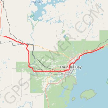
Shebandowan - Shuniah
- Distance: 58.0 mi
- Elevation gain: 1,588 ft
- Maximum elevation: 1,460 ft
- Elevation loss: 2,211 ft
- Minimum elevation: 607 ft
Interactive trail map
Make a donation
Gear up for your next adventure:
As an Amazon Associate, this site earns from qualifying purchases at no extra cost to you.
Trail profile
- Distance: 58.0 mi
- Elevation gain: 1,588 ft
- Maximum elevation: 1,460 ft
- Elevation loss: 2,211 ft
- Minimum elevation: 607 ft
Make a donation
Gear up for your next adventure:
As an Amazon Associate, this site earns from qualifying purchases at no extra cost to you.
About this trail
Name: Shebandowan - Shuniah trail, distance, elevation, map, profile, GPS track
Coordinates: 48.38002 -89.85956 48.58874 -88.96156
Make a donation
Gear up for your next adventure:
As an Amazon Associate, this site earns from qualifying purchases at no extra cost to you.
Other hiking, mountain biking, running and outdoor activity trails
Click on a trail to view its statistics, map and profile.
Shebandowan - Shuniah
Canada > Ontario > Thunder Bay District > Unorganized Thunder Bay District > Sunshine
Lake Superior. #Bike #Shebandowan #Shuniah #LakeSuperior
Distance: 46.7 mi • Elevation gain: 1,660 ft • Maximum elevation: 1,499 ft