Make a donation
Gear up for your next adventure:
As an Amazon Associate, this site earns from qualifying purchases at no extra cost to you.
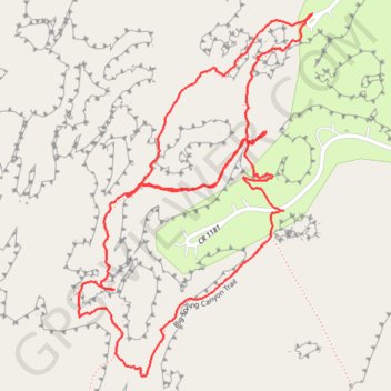
Hiking Canyonlands Needles
Loop hike via Squaw Flat Loop, Big Spring Canyon Trail in the Needles Districtand and the Canyonlands National Park. #Hiking #Loop #Nature #Rock #Park
- Distance: 2.2 mi
- Elevation gain: 367 ft
- Maximum elevation: 5,295 ft
- Elevation loss: 367 ft
- Minimum elevation: 5,128 ft
- Moving time: 55 m 33 s
- Moving speed: 2.4 mph
- Maximum speed: 3.8 mph
- Total time: 1 h 2 m
- Global speed: 2.1 mph
Interactive trail map
Make a donation
Gear up for your next adventure:
As an Amazon Associate, this site earns from qualifying purchases at no extra cost to you.
Trail profile
- Distance: 2.2 mi
- Elevation gain: 367 ft
- Maximum elevation: 5,295 ft
- Elevation loss: 367 ft
- Minimum elevation: 5,128 ft
- Moving time: 55 m 33 s
- Moving speed: 2.4 mph
- Maximum speed: 3.8 mph
- Total time: 1 h 2 m
- Global speed: 2.1 mph
Make a donation
Gear up for your next adventure:
As an Amazon Associate, this site earns from qualifying purchases at no extra cost to you.
About this trail
Name: Hiking Canyonlands Needles trail, distance, elevation, map, profile, GPS track
Coordinates: 38.14012 -109.80874 38.14761 -109.80258
Topography: San Juan County topographic map, elevation, terrain
Make a donation
Gear up for your next adventure:
As an Amazon Associate, this site earns from qualifying purchases at no extra cost to you.
Other hiking, mountain biking, running and outdoor activity trails
Click on a trail to view its statistics, map and profile.