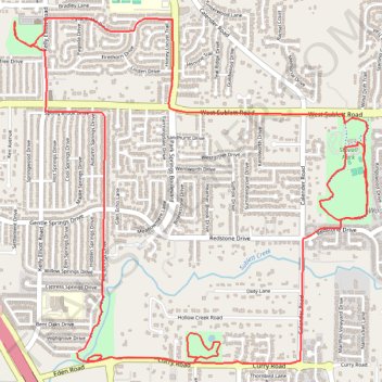
Bicycle ride though Deaver Park, Stoval Park, Allan Saxe Park, and Sublet Linear Park in Arlington TX
- Distance: 7.2 mi
- Elevation gain: 167 ft
- Maximum elevation: 679 ft
- Elevation loss: 167 ft
- Minimum elevation: 623 ft
- Moving time: 51 m 45 s
- Moving speed: 8.3 mph
- Maximum speed: 14.3 mph
- Total time: 56 m 30 s
- Global speed: 7.6 mph
Interactive trail map
Trail profile
- Distance: 7.2 mi
- Elevation gain: 167 ft
- Maximum elevation: 679 ft
- Elevation loss: 167 ft
- Minimum elevation: 623 ft
- Moving time: 51 m 45 s
- Moving speed: 8.3 mph
- Maximum speed: 14.3 mph
- Total time: 56 m 30 s
- Global speed: 7.6 mph
About this trail
Name: Bicycle ride though Deaver Park, Stoval Park, Allan Saxe Park, and Sublet Linear Park in Arlington TX trail, distance, elevation, map, profile, GPS track
Start: 6714, Big Springs Drive, Arlington, Tarrant County, Texas, 76001, United States (32.63506 -97.17329)
End: 6717, Big Springs Drive, Arlington, Tarrant County, Texas, 76001, United States (32.63499 -97.17336)
Coordinates: 32.63437 -97.17762 32.65411 -97.15365
Topography: Arlington topographic map, elevation, terrain