Thank you for supporting this site ❤️
Make a donation
Make a donation
Gear up for your next adventure:
As an Amazon Associate, this site earns from qualifying purchases at no extra cost to you.
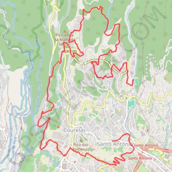
TRAIL 17km.
- Distance: 9.7 mi
- Elevation gain: 3,550 ft
- Maximum elevation: 2,717 ft
- Elevation loss: 3,251 ft
- Minimum elevation: 764 ft
Interactive trail map
Thank you for supporting this site ❤️
Make a donation
Make a donation
Gear up for your next adventure:
As an Amazon Associate, this site earns from qualifying purchases at no extra cost to you.
Trail profile
- Distance: 9.7 mi
- Elevation gain: 3,550 ft
- Maximum elevation: 2,717 ft
- Elevation loss: 3,251 ft
- Minimum elevation: 764 ft
Thank you for supporting this site ❤️
Make a donation
Make a donation
Gear up for your next adventure:
As an Amazon Associate, this site earns from qualifying purchases at no extra cost to you.
About this trail
Name: TRAIL 17km. trail, distance, elevation, map, profile, GPS track
Coordinates: 32.65910 -16.95651 32.68883 -16.93515
Thank you for supporting this site ❤️
Make a donation
Make a donation
Gear up for your next adventure:
As an Amazon Associate, this site earns from qualifying purchases at no extra cost to you.
Other hiking, mountain biking, running and outdoor activity trails
Click on a trail to view its statistics, map and profile.
Passeio aniversario nsr
Route created on plotaroute.com
Distance: 36.8 mi • Elevation gain: 10,154 ft • Maximum elevation: 3,573 ft