Make a donation
Gear up for your next adventure:
As an Amazon Associate, this site earns from qualifying purchases at no extra cost to you.
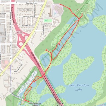
Minnesota Valley National Wildlife Refuge Hiking - Bass Ponds to Old Cedar Ave bridge
- Distance: 3.8 mi
- Elevation gain: 207 ft
- Maximum elevation: 804 ft
- Elevation loss: 184 ft
- Minimum elevation: 696 ft
- Moving time: 1 h 10 m
- Moving speed: 3.2 mph
- Maximum speed: 4.3 mph
- Total time: 1 h 11 m
- Global speed: 3.2 mph
Interactive trail map
Make a donation
Gear up for your next adventure:
As an Amazon Associate, this site earns from qualifying purchases at no extra cost to you.
Trail profile
- Distance: 3.8 mi
- Elevation gain: 207 ft
- Maximum elevation: 804 ft
- Elevation loss: 184 ft
- Minimum elevation: 696 ft
- Moving time: 1 h 10 m
- Moving speed: 3.2 mph
- Maximum speed: 4.3 mph
- Total time: 1 h 11 m
- Global speed: 3.2 mph
Make a donation
Gear up for your next adventure:
As an Amazon Associate, this site earns from qualifying purchases at no extra cost to you.
About this trail
Name: Minnesota Valley National Wildlife Refuge Hiking - Bass Ponds to Old Cedar Ave bridge trail, distance, elevation, map, profile, GPS track
Start: East 86th Street, Bloomington, Hennepin County, Minnesota, 55425, United States (44.84716 -93.23383)
End: East 86th Street, Bloomington, Hennepin County, Minnesota, 55425, United States (44.84776 -93.23585)
Coordinates: 44.83055 -93.24470 44.84780 -93.23016
Topography: Hennepin County topographic map, elevation, terrain
Make a donation
Gear up for your next adventure:
As an Amazon Associate, this site earns from qualifying purchases at no extra cost to you.
Other hiking, mountain biking, running and outdoor activity trails
Click on a trail to view its statistics, map and profile.
Fort Snelling State Park Minnesota River Greenway Loop
United States > Minnesota > Hennepin County > Bloomington
Distance: 9.9 mi • Elevation gain: 387 ft • Maximum elevation: 827 ft
Bike Ride on Minnesota Valley State Trail
United States > Minnesota > Hennepin County > Bloomington
Distance: 11.6 mi • Elevation gain: 331 ft • Maximum elevation: 810 ft