Thank you for supporting this site ❤️
Make a donation
Make a donation
Gear up for your next adventure:
As an Amazon Associate, this site earns from qualifying purchases at no extra cost to you.
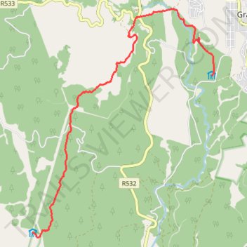
Fanie Botha Mac Mac Hut to Graskop Hut
- Distance: 7.8 mi
- Elevation gain: 919 ft
- Maximum elevation: 5,364 ft
- Elevation loss: 1,539 ft
- Minimum elevation: 4,498 ft
- Moving time: 3 h 2 m
- Moving speed: 2.6 mph
- Maximum speed: 3.8 mph
- Total time: 4 h 48 m
- Global speed: 1.6 mph
Interactive trail map
Thank you for supporting this site ❤️
Make a donation
Make a donation
Gear up for your next adventure:
As an Amazon Associate, this site earns from qualifying purchases at no extra cost to you.
Trail profile
- Distance: 7.8 mi
- Elevation gain: 919 ft
- Maximum elevation: 5,364 ft
- Elevation loss: 1,539 ft
- Minimum elevation: 4,498 ft
- Moving time: 3 h 2 m
- Moving speed: 2.6 mph
- Maximum speed: 3.8 mph
- Total time: 4 h 48 m
- Global speed: 1.6 mph
Thank you for supporting this site ❤️
Make a donation
Make a donation
Gear up for your next adventure:
As an Amazon Associate, this site earns from qualifying purchases at no extra cost to you.
About this trail
Name: Fanie Botha Mac Mac Hut to Graskop Hut trail, distance, elevation, map, profile, GPS track
Coordinates: -24.98719 30.78057 -24.92991 30.83068
Thank you for supporting this site ❤️
Make a donation
Make a donation
Gear up for your next adventure:
As an Amazon Associate, this site earns from qualifying purchases at no extra cost to you.
Other hiking, mountain biking, running and outdoor activity trails
Click on a trail to view its statistics, map and profile.
Fanie Botha Stables Hut to Mac Mac Hut via Mount Moodie
South Africa > Mpumalanga > Ehlanzeni District Municipality > Thaba Chweu Local Municipality > Mount Anderson
Distance: 10.3 mi • Elevation gain: 2,352 ft • Maximum elevation: 6,752 ft